
Faça uma doação
Mapa topográfico Signal Hill
Clique no mapa para exibir a altitude.
Faça uma doação
Sobre este mapa
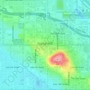
Nome: Mapa topográfico Signal Hill, altitude, relevo.
Local: Signal Hill, Los Angeles County, California, United States (33.78979 -118.18493 33.81891 -118.14963)
Altitude média: 28 m
Altitude mínima: 3 m
Altitude máxima: 108 m
Faça uma doação
Outros mapas topográficos
Clique em um mapa para visualizar sua topografia, sua altitude e seu relevo.
Placerville
United States > California > Placerville
The region east of Placerville, popularly known as Apple Hill and Pleasant Valley, is becoming a center for wine production. The wine region is officially designated as the El Dorado AVA. The largest wineries in the area are Boeger, Lava Cap and Madrona, but most of the 30 plus wineries surrounding Placerville…
Altitude média: 587 m
Sebastopol
United States > California > Sonoma County
Sebastopol's elevation is 65 to 250 feet (20 to 76 meters) above sea level. Its downtown is at the intersection of State Route 12 and State Route 116 (Gravenstein Highway), approximately 9 mi (14 km) west of U.S. Route 101.
Altitude média: 69 m
Faça uma doação
Bolsa Chica Wetlands
United States > California > Orange County > Huntington Beach
Altitude média: 7 m
General Sherman Tree
United States > California > Tulare County
General Sherman is a giant sequoia (Sequoiadendron giganteum) tree located at an elevation of 2,109 m (6,919 ft) above sea level in the Giant Forest of Sequoia National Park in Tulare County, in the U.S. state of California. By volume, it is the largest known living single-stem tree on Earth.
Altitude média: 2.114 m
Faça uma doação
Mountain House
United States > California > San Joaquin County
Mountain House lies on the foothills of the Diablo Range, and close to the Altamont Pass which is over 1,000 feet in elevation. It is on the border of Alameda and Contra Costa counties. According to the United States Census Bureau, the CDP covers an area of 3.2 square miles (8.3 km2), all of it land. The…
Altitude média: 22 m
Idyllwild-Pine Cove
United States > California > Riverside County
"Mile-high Idyllwild" is a mountain resort about one-mile (1,600 m) in altitude. Idyllwild is flanked by two large rock formations, Tahquitz Peak and Suicide Rock (also known as Lily Rock), which are famous in Southern California rock-climbing circles. It offers no skiing, so "the Hill" has been minimally…
Altitude média: 1.746 m
Fort Bragg
United States > California > Mendocino County
Fort Bragg, officially the City of Fort Bragg, is a city along the Pacific Coast of California along Shoreline Highway in Mendocino County. The city is 24 miles (39 km) west of Willits, at an elevation of 85 feet (26 m). Its population was 6,983 at the 2020 census.
Altitude média: 8 m
Faça uma doação
Twentynine Palms
United States > California > Twentynine Palms
According to the United States Census Bureau, the city has a total area of 59.1 square miles (153 km2), all land. The city is at an elevation of 1,988 feet (606 m). The Marine Corps Air Ground Combat Center Twentynine Palms is located there.
Altitude média: 690 m
Faça uma doação
Faça uma doação
Faça uma doação
Yucca Valley
United States > California > San Bernardino County
Yucca Valley lies in the middle of the Morongo Basin at a base elevation of 3,300 feet. Joshua Tree National Park is adjacent to its southern border.
Altitude média: 1.106 m
Bear Valley
United States > California > Alpine County
Bear Valley's central Sierra location and elevation gives it a warm-summer Mediterranean climate that is nearly a subarctic climate. Precipitation is seen for a lot of the year except for the middle of the summer, which can experience rare, but not unseen, thunderstorms. Late fall to early spring brings in…
Altitude média: 2.280 m
Faça uma doação
Rancho Santa Fe
The climate of Rancho Santa Fe is, for the most part, typical of the San Diego metropolitan area though its higher elevation and inland location lends itself to larger temperature variations.
Altitude média: 62 m
Susanville
United States > California > Lassen County
Susanville (formerly known as Rooptown) is a town in and is the county seat of Lassen County, California, United States. Susanville is located on the Susan River in the southern part of the county, at an elevation of 4,186 feet (1,276 m). Its population is 16,728 as of the 2020 census, down from 17,947 from…
Altitude média: 1.345 m
Lancaster
United States > California > Lancaster
According to the United States Census Bureau, the city has a total area of 94.5 square miles (245 km2), of which 94.3 square miles (244 km2) is land and 0.3 square miles (0.78 km2) (0.29%) is water. Lancaster's elevation is 2,350 feet (720 m) above sea level on a high, flat valley surrounded by pristine…
Altitude média: 787 m
Faça uma doação
Morgan Hill
United States > California > Santa Clara County > Morgan Hill
Morgan Hill is approximately 39 km (24 mi) south of downtown San Jose, 21 km (13 mi) north of Gilroy, and 24 km (15 mi) inland from the Pacific coast. Lying in a roughly 6 km-wide (4-mi-wide) southern extension of the Santa Clara Valley, it is bounded by the Santa Cruz Mountains to the west and the Diablo…
Altitude média: 145 m
Cassel
United States > California > Shasta County
Cassel is a census-designated place (CDP) in Shasta County, California. Cassel sits at an elevation of 3,176 feet (968 m). Its population is 207 as of the 2020 census, remaining the same from the 2010 census. The ZIP Code is 96016. The community is inside area code 530.
Altitude média: 972 m
Faça uma doação
Faça uma doação
Faça uma doação
Faça uma doação
Faça uma doação
Lake Del Valle
United States > California > Alameda County
The dam is 230 feet (70 m) high and 880 feet (270 m) long. Its crest elevation is 773 feet (236 m). The dam contains 4,150,000 cubic yards (3,170,000 m3) of earth fill.
Altitude média: 339 m
Faça uma doação
Mammoth Lakes
United States > California > Mammoth Lakes
Mammoth Lakes is a town in Mono County, California, the county's only incorporated community. It is located immediately to the east of Mammoth Mountain, at an elevation of 7,880 feet (2,400 m). As of the 2010 United States Census, the population was 8,234, reflecting a 16% increase from the 2000 Census.
Altitude média: 2.184 m
Faça uma doação
Independence
Independence is a census-designated place in Inyo County, California. Independence is located 41 miles (66 km) south-southeast of Bishop, at an elevation of 3930 feet (1198 m). It is the county seat of Inyo County, California. The population of this census-designated place was 669 at the 2010 census, up from…
Altitude média: 1.199 m
Faça uma doação
Faça uma doação
Faça uma doação
Faça uma doação
San Diego
United States > California > San Diego County > San Diego
The climate in San Diego, like most of Southern California, often varies significantly over short geographical distances, resulting in microclimates. In San Diego, this is mostly because of the city's topography (the Bay, and the numerous hills, mountains, and canyons). Frequently, particularly during the "May…
Altitude média: 57 m
San Geronimo
United States > California > Marin County
San Geronimo (Spanish: San Gerónimo, meaning "St. Jerome") is a census-designated place (CDP) located in the San Geronimo Valley in Marin County, California in the United States. San Geronimo is located with Lagunitas-Forest Knolls to its west, Woodacre to its east, and 8 miles (13 km) southwest of downtown…
Altitude média: 234 m
Newbury Park
United States > California > Ventura County > Thousand Oaks
Newbury Park can be described as a town,[6] community,[94] or section[9] mostly within the Thousand Oaks city limits in addition to rural areas west of Thousand Oaks. Newbury Park is bordered by Lynn Road in the east and the Conejo Grade on the west. It borders the Santa Monica Mountains in the south, while…
Altitude média: 262 m
Faça uma doação
Faça uma doação
Faça uma doação
Faça uma doação
Faça uma doação
Lafayette Reservoir
United States > California > Contra Costa County > Lafayette
Altitude média: 174 m
Crescent City
United States > California > Del Norte County
The topography of the sea floor surrounding Crescent City has the effect of focusing tsunamis. According to researchers at Humboldt State University and the University of Southern California, the city experienced tsunami conditions 31 times between the years 1933 and 2008. Although many of these incidents were…
Altitude média: 31 m
Faça uma doação