
Faça uma doação
Mapa topográfico Gorman
Clique no mapa para exibir a altitude.
Faça uma doação
Sobre este mapa
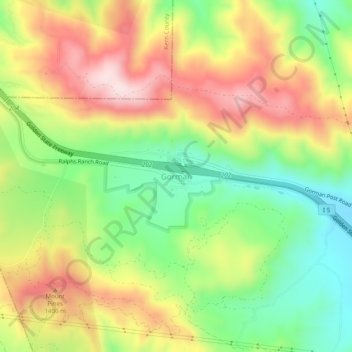
Nome: Mapa topográfico Gorman, altitude, relevo.
Altitude média: 1.285 m
Altitude mínima: 1.099 m
Altitude máxima: 1.500 m
Faça uma doação
Outros mapas topográficos
Clique em um mapa para visualizar sua topografia, sua altitude e seu relevo.
Pacific Palisades
United States > California > Los Angeles County > Los Angeles
Pacific Palisades was formally founded in 1921 by a Methodist organization, and in the years that followed became a refuge for Jewish artists and intellectuals fleeing the Holocaust. The Palisades would later be sought after by celebrities and other high-profile individuals seeking privacy. It is known for its…
Altitude média: 196 m
Santa Ynez Reservoir
United States > California > Los Angeles County > Los Angeles
Altitude média: 307 m
Faça uma doação
Faça uma doação
Faça uma doação
Los Angeles City Council District 7
United States > California > Los Angeles County > Los Angeles
Altitude média: 512 m
Faça uma doação
West Hills Neighborhood Council District
United States > California > Los Angeles County > Los Angeles
Altitude média: 319 m
Angeles National Forest
United States > California > Los Angeles County
The Angeles National Forest manages the habitats, flora and fauna ecosystems, and watersheds. Some of the rivers with watersheds within its boundaries provide valuable non-groundwater recharge water for Southern California. The existing protected and restored native vegetation absorb and slow surface runoff of…
Altitude média: 782 m
Faça uma doação
Mount Wilson Observatory
United States > California > Los Angeles County > Mount Wilson
Altitude média: 1.421 m
Los Angeles City Council District 5
United States > California > Los Angeles County > Los Angeles
Altitude média: 131 m
Faça uma doação
Faça uma doação
Lake Elizabeth
United States > California > Los Angeles County
The lake, at 984 m (3,228 ft) in elevation, is within the Angeles National Forest. It is a natural perennial lake, but may dry up entirely during drought years. It is south of the western Antelope Valley.
Altitude média: 1.065 m
Faça uma doação
Topanga State Park
United States > California > Los Angeles County > Los Angeles
Altitude média: 333 m
Faça uma doação
Runyon Canyon Park
United States > California > Los Angeles County > Los Angeles
Altitude média: 235 m
Val Verde
United States > California > Los Angeles County
Val Verde is located in the San Martinez Chiquito Canyon in the southeastern foothills of the Topatopa Mountains at an elevation ranging from 1,250–1,400 feet (380–430 m). The canyon contains a creek with runs intermittently through the community. It is about 50 miles (80 km) northwest of the county seat…
Altitude média: 440 m
Faça uma doação
Faça uma doação
Avocado Heights
United States > California > Los Angeles County > Avocado Heights
Altitude média: 112 m
Faça uma doação
Los Angeles City Council District 6
United States > California > Los Angeles County > Los Angeles
Altitude média: 252 m
Arleta Neighborhood Council District
United States > California > Los Angeles County > Los Angeles
Altitude média: 274 m
Faça uma doação
Santa Susana Mountains
United States > California > Los Angeles County > Unincorporated Chatsworth
Altitude média: 546 m
Stoneview Nature Center
United States > California > Los Angeles County > Culver City
Altitude média: 64 m
Faça uma doação
Golden Shore Marine Biological Reserve
United States > California > Los Angeles County > Long Beach
Altitude média: 7 m
Faça uma doação
Edward Vincent Jr. Park
United States > California > Los Angeles County > Inglewood
Altitude média: 56 m
Faça uma doação
Augustus F. Hawkins Natural Park
United States > California > Los Angeles County > Los Angeles
Altitude média: 55 m
La Puerta Sports Park
United States > California > Los Angeles County > Claremont
Altitude média: 471 m
Faça uma doação
Whittier Narrows
United States > California > Los Angeles County > South El Monte
Altitude média: 75 m
Genesee Avenue Park
United States > California > Los Angeles County > Los Angeles
Altitude média: 33 m
East Rancho Dominguez County Park
United States > California > Los Angeles County > East Compton
Altitude média: 22 m