
Faça uma doação
Mapa topográfico Thousand Oaks
Clique no mapa para exibir a altitude.
Faça uma doação
Thousand Oaks
The northern parts consist of mountainous terrain in the Simi Hills, Conejo Mountains and Mount Clef Ridge. Narrow canyons such as Hill Canyon cut through the steeper mountainous areas. Conejo Mountain and Conejo Grade are found in westernmost Newbury Park, while the southernmost parts of Thousand Oaks are made up of Russell Valley, Hidden Valley and the steep rugged slopes of the Santa Monica Mountains. The elevation ranges from 500 feet in the northwest to the 2,403 feet Simi Peak. The major drainage is Conejo Creek (Arroyo Conejo).
Faça uma doação
Sobre este mapa
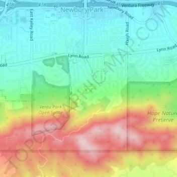
Nome: Mapa topográfico Thousand Oaks, altitude, relevo.
Local: Thousand Oaks, Ventura County, California, United States (34.17084 -118.91146 34.17228 -118.90929)
Altitude média: 303 m
Altitude mínima: 191 m
Altitude máxima: 486 m
Faça uma doação
Outros mapas topográficos
Clique em um mapa para visualizar sua topografia, sua altitude e seu relevo.
Newbury Park
United States > California > Ventura County > Thousand Oaks
Newbury Park can be described as a town,[6] community,[94] or section[9] mostly within the Thousand Oaks city limits in addition to rural areas west of Thousand Oaks. Newbury Park is bordered by Lynn Road in the east and the Conejo Grade on the west. It borders the Santa Monica Mountains in the south, while…
Altitude média: 262 m
Ventu Park
United States > California > Ventura County > Thousand Oaks > Newbury Park
Altitude média: 250 m
Faça uma doação