
Faça uma doação
Mapa topográfico Solvang
Clique no mapa para exibir a altitude.
Faça uma doação
Solvang
Solvang is located at 34°35′38″N 120°8′23″W / 34.59389°N 120.13972°W / 34.59389; -120.13972. At an elevation of 505 ft (154 m), it lies in the Santa Ynez Valley some 46 miles (74 km) north-west of Santa Barbara and about 15 miles (24 km) north of the Pacific coast. According to the United States Census Bureau, the city has a total area of 2.4 square miles (6.2 km2), 99.95% of it land and 0.05% of it water.
Faça uma doação
Sobre este mapa
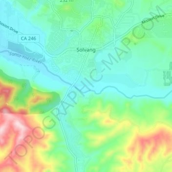
Nome: Mapa topográfico Solvang, altitude, relevo.
Local: Solvang, Santa Barbara County, California, United States (34.55889 -120.15491 34.61077 -120.11992)
Altitude média: 194 m
Altitude mínima: 102 m
Altitude máxima: 442 m
Faça uma doação
Outros mapas topográficos
Clique em um mapa para visualizar sua topografia, sua altitude e seu relevo.
Mission Canyon
United States > California > Santa Barbara County
The approximate center of Mission Canyon is located at 34°26′59″N 119°42′59″W / 34.44972°N 119.71639°W / 34.44972; -119.71639 (34.449797, -119.716315). Situated along the southern facing slopes of the Santa Ynez Mountains, Mission Canyon measures some 1,122 acres comprising an estimated…
Altitude média: 199 m
Faça uma doação
Faça uma doação
Faça uma doação