
Faça uma doação
Mapa topográfico June Lake
Clique no mapa para exibir a altitude.
Faça uma doação
June Lake
June Lake is an unincorporated community and census-designated place (CDP) in Mono County, California, United States. It is located against the southern rim of the Mono Basin, 12.5 miles (20 km) south of Lee Vining, at an elevation of 7,654 feet (2,333 m).
Faça uma doação
Sobre este mapa
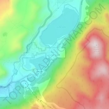
Nome: Mapa topográfico June Lake, altitude, relevo.
Local: June Lake, Mono County, California, 93529, United States (37.75853 -119.09625 37.79853 -119.05625)
Altitude média: 2.548 m
Altitude mínima: 2.271 m
Altitude máxima: 2.973 m
Faça uma doação
Outros mapas topográficos
Clique em um mapa para visualizar sua topografia, sua altitude e seu relevo.
Mono Lake
United States > California > Mono County
Lake Russell was the prehistoric predecessor to Mono Lake, during the Pleistocene. Its shoreline reached the modern-day elevation of 7,480 feet (2,280 m), about 1,100 feet (330 m) higher than the present-day lake. As of 1.6 million years ago, Lake Russell discharged to the northeast, into the Walker River…
Altitude média: 2.008 m
Faça uma doação
Faça uma doação