
Faça uma doação
Mapa topográfico Loveland Pass
Clique no mapa para exibir a altitude.
Faça uma doação
Loveland Pass
Loveland Pass is a high mountain pass in north-central Colorado, at an elevation of 11,990 feet (3,655 m) above sea level in the Rocky Mountains of the Western United States.
Faça uma doação
Sobre este mapa
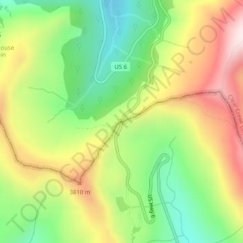
Nome: Mapa topográfico Loveland Pass, altitude, relevo.
Altitude média: 3.639 m
Altitude mínima: 3.347 m
Altitude máxima: 4.001 m
Faça uma doação
Outros mapas topográficos
Clique em um mapa para visualizar sua topografia, sua altitude e seu relevo.
Denver
United States > Colorado > Denver County > Denver
Denver, situated at an elevation of 5,280 feet (1,609 meters), is renowned as the "Mile High City." It is located in the South Platte River Valley, just east of the Rocky Mountains' foothills. The city's topography features a gently sloping landscape characterized by rolling hills and wide valleys,…
Altitude média: 1.684 m
Air Force Academy
United States > Colorado > El Paso County > Colorado Springs
The campus of the academy covers 18,455 acres (29 sq mi; 75 km2) on the east side of the Rampart Range of the Rocky Mountains, just north of Colorado Springs. Its elevation is normally given as 7,258 feet (2,212 m) above sea level, which is at the cadet area. The academy was designed by Skidmore, Owings and…
Altitude média: 2.158 m
Monument
United States > Colorado > Monument
Monument is situated at an elevation of approximately 7,000 feet (2,134 meters) within the Front Range of the Rocky Mountains, creating a diverse topography that is both striking and varied. The town is characterized by rolling hills and flat terrain in the valley, contrasted by the rugged foothills of the…
Altitude média: 2.133 m
Faça uma doação
Faça uma doação
Kim
United States > Colorado > Las Animas County
Kim is located on the plains of southeastern Colorado and the elevation is 5690 ft (1734 m).
Altitude média: 1.734 m
Mancos
United States > Colorado > Montezuma County
According to the United States Census Bureau, Mancos has a total area of 0.6 square miles (1.6 km2), all of it recorded as land. The town is located in the Mancos River valley at an elevation of approximately 7,000 feet (2,100 m). The Mancos River was named by Spanish explorers (Rio de los Mancos - "River of…
Altitude média: 2.158 m
Faça uma doação
Faça uma doação
Fraser
United States > Colorado > Grand County
Fraser is located in southeastern Grand County at 39°56′39″N 105°48′48″W / 39.94417°N 105.81333°W / 39.94417; -105.81333 (39.944158, -105.813355), at an elevation of 8,574 feet (2,613 m) above sea level. It is bordered to the south by the town of Winter Park and to the north by…
Altitude média: 2.696 m
Faça uma doação
Pike National Forest
Most of the forest experiences a Highland climate with warm summers and cold winters. Even in the summer, nights are cool due to the forest's high elevation. Temperatures and precipitation vary widely throughout the forest, depending on elevation. Most of the forest receives more than 100 inches of snow a year.
Altitude média: 2.568 m
Faça uma doação
Faça uma doação
Montrose
United States > Colorado > Montrose County
Montrose features a semi-arid Continental climate zone. The town sits on high grasslands in the Uncompahgre Valley of Western Colorado. Snowfall occurs during the winter but is usually short-lived due to the high altitude and abundant sunshine.
Altitude média: 1.803 m
Faça uma doação
Estes Park
United States > Colorado > Larimer County
Estes Park sits at an elevation of 7,522 feet (2,293 m) on the front range of the Rocky Mountains at the eastern entrance of the Rocky Mountain National Park. Its location is 40°22′22″N 105°31′09″W / 40.372856°N 105.519136°W / 40.372856; -105.519136. Its north, south and east extremities…
Altitude média: 2.409 m
Faça uma doação
Lakewood
United States > Colorado > Jefferson County > Lakewood
Lakewood is located at 39°42′17″N 105°04′53″W / 39.70472°N 105.08139°W / 39.70472; -105.08139 at an elevation of 5,518 feet (1,682 m). Located at the junction of U.S. Route 6 and Colorado State Highway 121 in central Colorado, the city lies immediately west of Denver and 62 miles (100 km)…
Altitude média: 1.717 m
Rye
United States > Colorado > Pueblo County
Rye has a subtropical highland climate (Köppen Cfb), a climate type usually associated with maritime regions, but is also found in high elevation areas in which summer temperatures are moderated by altitude. Precipitation exceeds that of semi-arid places, and average winter temperatures exceed freezing (O°C,…
Altitude média: 2.090 m
Faça uma doação
Vail
United States > Colorado > Eagle County
Vail's average elevation is 8,150 feet (2484 m) above sea level. The town has a total area of 4.5 square miles (12 km2), with no lakes (there is, however, at least one pond). Gore Creek flows from east to west through the center of town.
Altitude média: 2.953 m
Walden
United States > Colorado > Jackson County
Walden is the Statutory Town that is the county seat, the most populous community, and the only incorporated municipality in Jackson County, Colorado, United States. It is situated in the center of a large open valley called North Park. People from Walden and the surrounding area refer to themselves as "North…
Altitude média: 2.463 m
Gunnison
United States > Colorado > Gunnison County
Also in 1880, the cattle industry in Gunnison was established. Realizing the poor conditions for farming (with only about eleven inches of rainfall annually and the short growing season due to the high elevation and alpine environment) the local farmers turned to ranching and began breeding cattle. To do this…
Altitude média: 2.369 m
Faça uma doação
Arapahoe County Fairgrounds and Regional Park
United States > Colorado > Arapahoe County > Aurora
Altitude média: 1.783 m
University of Colorado Boulder (Williams Village)
United States > Colorado > Boulder County > Boulder
Altitude média: 1.634 m
Faça uma doação
Faça uma doação
Faça uma doação
Victor
United States > Colorado > Teller County
In 2022, youtubers The Baseball Bat Bros attempted to break the Guinness World Record for Longest home run hit, set by Babe Ruth in 1921 with a verified measurement of 575 feet. The attempt was made at The Gold Bowl baseball and soccer field. Victor, having one of the highest elevations in the United States…
Altitude média: 2.974 m
Faça uma doação
Fredrick Law Olmsted, Jr. Park
United States > Colorado > Boulder County > Boulder
Altitude média: 1.664 m
Faça uma doação
Faça uma doação
Manassa
United States > Colorado > Conejos County
Manassa's elevation is 7,683 feet (2,342 m) above sea level. The land within Manassa city limits is entirely flat, with rolling hills nearby. Foothills and mountains (taller than 14,000 feet (4,300 m)) are farther in each direction, including the Sangre de Cristo Range to the east and the San Juan Mountains to…
Altitude média: 2.344 m
Faça uma doação
Nederland
United States > Colorado > Boulder County
In 1873 the Caribou Mine, at an elevation of roughly 10,000 feet (3,000 m) and 6 miles (10 km) northwest of the town, was sold to the Mining Company Nederland from the Netherlands. The high elevation meant fierce winds and deep winter snow, so the new owners of the mine decided that it was beneficial to bring…
Altitude média: 2.578 m
Faça uma doação
Silverton
United States > Colorado > San Juan County
According to the United States Census Bureau, the town has a total area of 0.8 square miles (2.1 km2), all of it land. Silverton is one of the highest towns in the United States, at 9,318 feet (2,840 m) above sea level. The town is located in San Juan County, the highest county in the United States, with a…
Altitude média: 2.991 m
Faça uma doação
Yampa
United States > Colorado > Routt County
Yampa has a humid continental climate (Köppen climate classification Dfb), with warm summers and long, cold, snowy winters. Due to altitude and dryness, the diurnal temperature variation is large throughout the year, especially in summer, and the growing season is short, typically averaging just 80 days.
Altitude média: 2.422 m
Pawnee National Grassland
United States > Colorado > Weld County
The grassland is a part of the short grass plains of North America. The best example of this ecosystem are preserved around the Pawnee Buttes where grazing and intensive agriculture have had less impact. There are eleven vegetation zones represented with the most unique being the scarp woodlands on the north…
Altitude média: 1.510 m
Faça uma doação
Faça uma doação
Lake Pueblo State Park
United States > Colorado > Pueblo County
Lake Pueblo (also known as Pueblo Reservoir) has a maximum depth of 135 feet (41 m) and is impounded by Pueblo Dam. Its surface elevation is 4,826 feet (1,471 meters).
Altitude média: 1.523 m
Faça uma doação
Rawah Wilderness
United States > Colorado > Larimer County
The Rawah Wilderness is administered by the USDA Forest Service. It is located on the Canyon Lakes Ranger District of the Roosevelt National Forest in Colorado, near the Wyoming border, and also in the Routt National Forest to its south. It encompasses 76,394 acres (309.16 km2) and includes 25 named lakes…
Altitude média: 2.898 m
Faça uma doação
Faça uma doação