
Mapa topográfico Silverton
Clique no mapa para exibir a altitude.
Silverton
According to the United States Census Bureau, the town has a total area of 0.8 square miles (2.1 km2), all of it land. Silverton is one of the highest towns in the United States, at 9,318 feet (2,840 m) above sea level. The town is located in San Juan County, the highest county in the United States, with a mean elevation of 11,240 feet (3,430 meters). Silverton sits in a flat area of the Animas River valley and is surrounded by several thirteeners, the highest being Storm Peak, at 13,487 feet. The town is less than 15 miles from seven of Colorado's 53 "fourteeners", i.e., mountain peaks with a summit elevation of at least 14,000 feet (4,300 meters).
Sobre este mapa
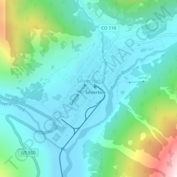
Nome: Mapa topográfico Silverton, altitude, relevo.
Local: Silverton, San Juan County, Colorado, 81433, United States (37.80055 -107.67702 37.82005 -107.65038)
Altitude média: 2.991 m
Altitude mínima: 2.811 m
Altitude máxima: 3.661 m
Outros mapas topográficos
Clique em um mapa para visualizar sua topografia, sua altitude e seu relevo.
Coal Bank Pass
United States > Colorado > San Juan County
Coal Bank Pass, elevation 10,640 feet (3,240 meters), is a mountain pass in the San Juan Mountains of western Colorado in the United States. The pass is in the San Juan National Forest.
Altitude média: 3.277 m