
Mapa topográfico Victor
Clique no mapa para exibir a altitude.
Victor
In 2022, youtubers The Baseball Bat Bros attempted to break the Guinness World Record for Longest home run hit, set by Babe Ruth in 1921 with a verified measurement of 575 feet. The attempt was made at The Gold Bowl baseball and soccer field. Victor, having one of the highest elevations in the United States was an ideal location as thinner air at high elevations creates less drag on a traveling baseball than at lower elevations, thus allowing it to travel farther in the air. Various high school, college, and former professional baseball players were invited to attempt to break the record but none were successful with elevated land beyond the outfield and unfavorable winds likely spoiling the attempts. The longest home run hit on the day was an estimated 534 feet.
Sobre este mapa
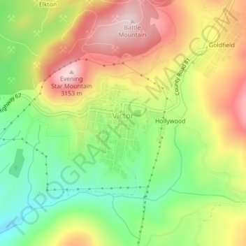
Nome: Mapa topográfico Victor, altitude, relevo.
Local: Victor, Teller County, Colorado, United States (38.70404 -105.14716 38.71428 -105.13556)
Altitude média: 2.974 m
Altitude mínima: 2.803 m
Altitude máxima: 3.160 m
Outros mapas topográficos
Clique em um mapa para visualizar sua topografia, sua altitude e seu relevo.
Woodland Park
United States > Colorado > Teller County > Woodland Park
Woodland Park experiences an alpine subarctic climate (Dfc), due to its high elevation and its location in the Rocky Mountains. Summers are warm, but much milder than summers at lower elevations, such as in Colorado Springs, Denver, or the plains to the east. Nights are cool, even chilly in summer.
Altitude média: 2.657 m