
Mapa topográfico Denver
Clique no mapa para exibir a altitude.
Denver
Denver, situated at an elevation of 5,280 feet (1,609 meters), is renowned as the "Mile High City." It is located in the South Platte River Valley, just east of the Rocky Mountains' foothills. The city's topography features a gently sloping landscape characterized by rolling hills and wide valleys, transitioning from the expansive High Plains to the west. The terrain is shaped by the nearby Rocky Mountains, with the peaks rising dramatically to the west and offering a striking contrast to the urban landscape. Denver's elevation ranges from approximately 4,973 feet (1,515 meters) at its lowest points to about 7,875 feet (2,397 meters) in the surrounding foothills, making it a unique blend of urban and mountainous environments.
Sobre este mapa
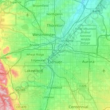
Nome: Mapa topográfico Denver, altitude, relevo.
Local: Denver, Denver County, Colorado, United States (39.61432 -105.10988 39.91421 -104.59969)
Altitude média: 1.684 m
Altitude mínima: 1.515 m
Altitude máxima: 2.397 m