
Mapa topográfico Silverthorne
Clique no mapa para exibir a altitude.
Sobre este mapa
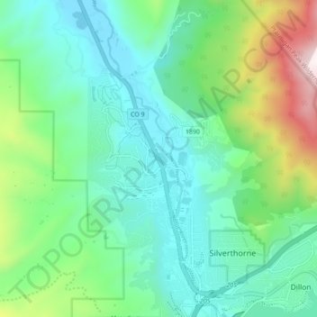
Nome: Mapa topográfico Silverthorne, altitude, relevo.
Altitude média: 2.858 m
Altitude mínima: 2.607 m
Altitude máxima: 3.612 m
Outros mapas topográficos
Clique em um mapa para visualizar sua topografia, sua altitude e seu relevo.
Hoosier Pass
United States > Colorado > Summit County
Hoosier Pass (elevation 11,542 ft (3,518 m)) is a high mountain pass in central Colorado, in the Rocky Mountains of the western United States. The name derives from Indiana, nicknamed the "Hoosier State," which was the original home of many pioneers.
Altitude média: 3.490 m
Boreas Pass
United States > Colorado > Summit County
Boreas Pass (elevation 11,481 ft (3,499 m)) is a high mountain pass in central Colorado, in the Rocky Mountains of the western United States. The pass is located on the continental divide, at the crest of the Front Range along the border between Park (south) and Summit counties.
Altitude média: 3.559 m