
Faça uma doação
Mapa topográfico Rawah Wilderness
Clique no mapa para exibir a altitude.
Faça uma doação
Rawah Wilderness
The Rawah Wilderness is administered by the USDA Forest Service. It is located on the Canyon Lakes Ranger District of the Roosevelt National Forest in Colorado, near the Wyoming border, and also in the Routt National Forest to its south. It encompasses 76,394 acres (309.16 km2) and includes 25 named lakes ranging in size from five to 39 acres (20,000 to 160,000 m2). There are 85 miles (137 km) of trails in the area and elevation ranges from 8,400 feet (2,600 m) to 13,000 feet (4,000 m). Much of the area is traversed by the Medicine Bow Mountains and the Rawah Range for which it is named. The temperature in the Rawah Wilderness ranges from a low of 5 °F (−15 °C) during the winter and a high of 77 °F (25 °C) during the summer.
Faça uma doação
Sobre este mapa
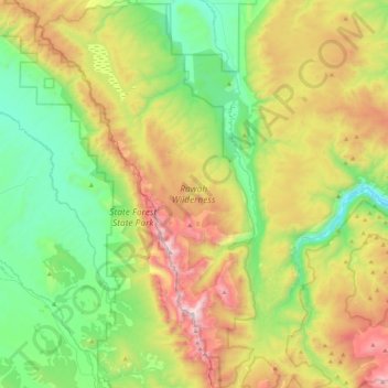
Nome: Mapa topográfico Rawah Wilderness, altitude, relevo.
Local: Rawah Wilderness, Larimer County, Colorado, United States (40.54226 -106.10853 40.87440 -105.85811)
Altitude média: 2.898 m
Altitude mínima: 2.344 m
Altitude máxima: 3.919 m
Faça uma doação
Outros mapas topográficos
Clique em um mapa para visualizar sua topografia, sua altitude e seu relevo.
Estes Park
United States > Colorado > Larimer County
Estes Park sits at an elevation of 7,522 feet (2,293 m) on the front range of the Rocky Mountains at the eastern entrance of the Rocky Mountain National Park. Its location is 40°22′22″N 105°31′09″W / 40.372856°N 105.519136°W / 40.372856; -105.519136. Its north, south and east extremities…
Altitude média: 2.409 m
Faça uma doação
Hallett Peak
United States > Colorado > Larimer County
According to the Köppen climate classification system, Hallett Peak is located in an alpine subarctic climate zone with cold, snowy winters, and cool to warm summers. Due to its altitude, it receives precipitation all year, as snow in winter and as thunderstorms in summer, with a dry period in late spring.
Altitude média: 3.577 m
Faça uma doação
Faça uma doação
Faça uma doação
Faça uma doação
Faça uma doação
Lake Estes
United States > Colorado > Larimer County > Estes Park > Stanley Heights Subdivision
Altitude média: 2.318 m
Faça uma doação
Browns Corner
United States > Colorado > Larimer County > Loveland > Browns Corner
Altitude média: 1.518 m
Estes Park
United States > Colorado > Larimer County > Estes Park > Estes Park
Altitude média: 2.461 m
Faça uma doação