
Mapa topográfico Ore Mountains
Clique no mapa para exibir a altitude.
Ore Mountains
The higher altitudes from around 500 m above sea level on the German side belong to the Ore Mountains/Vogtland Nature Park – the largest of its kind in Germany with a length of 120 km. The eastern Ore Mountains are protected landscape. Other smaller areas on the German and Czech sides are protected as nature reserves and natural monuments. On the ridges there are also several larger raised bogs that are only fed by rainwater. The mountains are popular for hiking and there are winter sports areas at higher elevations. In 2019, the region became a UNESCO World Heritage Site.
Sobre este mapa
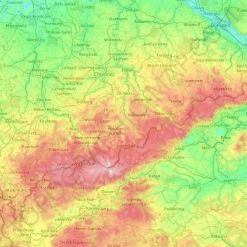
Nome: Mapa topográfico Ore Mountains, altitude, relevo.
Local: Ore Mountains, Saxony, Germany (50.19257 12.30729 51.02584 14.04725)
Altitude média: 443 m
Altitude mínima: 89 m
Altitude máxima: 1.238 m
Outros mapas topográficos
Clique em um mapa para visualizar sua topografia, sua altitude e seu relevo.
Upper Lusatia
The highest elevations of the German part of Upper Lusatia are in the Zittau Mountains (Lusatian Ridge), part of the Lusatian Mountains forming the border with the adjacent Bohemian region in the south, which today belong to the Czech Republic. The highest peaks of the Zittau Mountains are the Lausche at 792.6…
Altitude média: 260 m
Dresden
Dresden lies on both banks of the Elbe, mostly in the Dresden Basin, with the further reaches of the eastern Ore Mountains to the south, the steep slope of the Lusatian granitic crust to the north, and the Elbe Sandstone Mountains to the east at an altitude of about 113 metres (371 feet). Triebenberg is the…
Altitude média: 204 m
Saxon Switzerland National Park
Germany > Saxony > Sächsische Schweiz-Osterzgebirge
Altitude média: 356 m
Freiberg
Germany > Saxony > Mittelsachsen
The town lies on the northern declivity of the Ore Mountains, with the majority of the borough west of the Eastern or Freiberger Mulde river. Parts of the town are nestled in the valleys of Münzbach and Goldbach streams. Its centre has an altitude of about 412 m above sea level (NHN) (at the railway station).…
Altitude média: 405 m
Sebnitz
Germany > Saxony > Sächsische Schweiz-Osterzgebirge
The town of Sebnitz lies in the valley of the river Sebnitz and its side valleys between 251 and 460 m above sea level between the mountains of Saxon Switzerland and the Lusatian Highlands. Topographically the town itself lies in the West Lusatian Upland, but lies right on the border with the Upper Lusatian…
Altitude média: 342 m
Dresden
Dresden lies on both banks of the Elbe, mostly in the Dresden Basin, with the further reaches of the eastern Ore Mountains to the south, the steep slope of the Lusatian granitic crust to the north, and the Elbe Sandstone Mountains to the east at an altitude of about 113 metres (371 feet). Triebenberg is the…
Altitude média: 204 m
Reinhardtsgrimma
Germany > Saxony > Sächsische Schweiz-Osterzgebirge > Glashütte
Altitude média: 372 m