
Mapa topográfico Aue
Clique no mapa para exibir a altitude.
Sobre este mapa
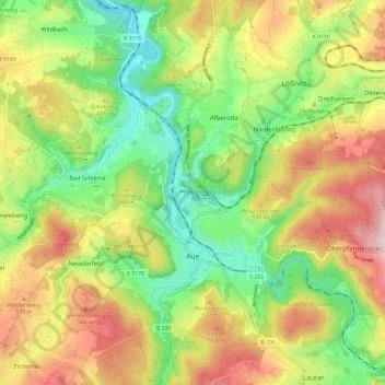
Nome: Mapa topográfico Aue, altitude, relevo.
Local: Aue, Aue-Bad Schlema, Erzgebirgskreis, Saxony, 08280, Germany (50.56151 12.65549 50.63743 12.73984)
Altitude média: 465 m
Altitude mínima: 315 m
Altitude máxima: 657 m
Outros mapas topográficos
Clique em um mapa para visualizar sua topografia, sua altitude e seu relevo.
Markersbach
Germany > Saxony > Erzgebirgskreis
In 1889, Markersbach was connected to the railway line from Schwarzenberg to Annaberg, which was closed to passenger transport on 27 September 1997. The station lay in Mittweida’s municipal area and the platform signs read Mittweida-Markersbach. To overcome the great elevation differential, the railway's…
Altitude média: 600 m