
Mapa topográfico Dresden
Clique no mapa para exibir a altitude.
Sobre este mapa
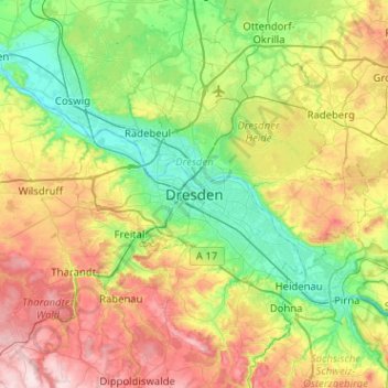
Nome: Mapa topográfico Dresden, altitude, relevo.
Local: Dresden, Saxony, 01069, Germany (50.88933 13.57814 51.20933 13.89814)
Altitude média: 237 m
Altitude mínima: 97 m
Altitude máxima: 498 m
Outros mapas topográficos
Clique em um mapa para visualizar sua topografia, sua altitude e seu relevo.
Innere Altstadt
Dresden lies on both banks of the Elbe, mostly in the Dresden Basin, with the further reaches of the eastern Ore Mountains to the south, the steep slope of the Lusatian granitic crust to the north, and the Elbe Sandstone Mountains to the east at an altitude of about 113 metres (371 feet). Triebenberg is the…
Altitude média: 117 m