
Mapa topográfico Freital
Clique no mapa para exibir a altitude.
Sobre este mapa
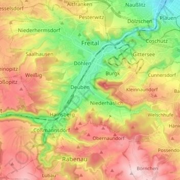
Nome: Mapa topográfico Freital, altitude, relevo.
Altitude média: 275 m
Altitude mínima: 127 m
Altitude máxima: 425 m
Outros mapas topográficos
Clique em um mapa para visualizar sua topografia, sua altitude e seu relevo.
Saxon Switzerland
Germany > Saxony > Sächsische Schweiz-Osterzgebirge
Saxon Switzerland forms the northern part of the Elbe Sandstone Mountains range, located on the German-Czech border. To the east, it transitions into the Lusatian Highlands and, to the west, into the Ore Mountains. The Czech part of the Elbe Sandstone Mountains is partly formed by the Bohemian Switzerland…
Altitude média: 341 m
Reinhardtsgrimma
Germany > Saxony > Sächsische Schweiz-Osterzgebirge > Glashütte
Altitude média: 372 m
Topograph
Germany > Saxony > Sächsische Schweiz-Osterzgebirge > Rosenthal-Bielatal
Altitude média: 385 m