
Faça uma doação
Mapa topográfico Aldridge
Clique no mapa para exibir a altitude.
Faça uma doação
Sobre este mapa
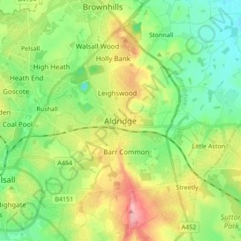
Nome: Mapa topográfico Aldridge, altitude, relevo.
Altitude média: 145 m
Altitude mínima: 96 m
Altitude máxima: 230 m
Faça uma doação
Outros mapas topográficos
Clique em um mapa para visualizar sua topografia, sua altitude e seu relevo.
Faça uma doação
Faça uma doação
West Yorkshire
Wakefield's Parish Church was raised to cathedral status in 1888 and after the elevation of Wakefield to diocese, Wakefield Council immediately sought city status and this was granted in July 1888. However the Industrial Revolution, which changed West and South Yorkshire significantly, led to the growth of…
Altitude média: 172 m
Faça uma doação
Faça uma doação
Dartmoor National Park
United Kingdom > England > Devon
Rainfall tends to be associated with Atlantic depressions or with convection. In summer, convection caused by solar surface heating sometimes forms shower clouds and a large proportion of rainfall falls from showers and thunderstorms at this time of year. The wettest months are November and December and on the…
Altitude média: 239 m
Faça uma doação
Aylesbury
United Kingdom > England > Aylesbury
Aylesbury is immediately southeast of the upper River Thame that flows past Thame to Dorchester on Thames and is partly sited on the two northernmost outcrops of Portland (lime)stone in England bisected by a small stream, Bear Brook which gives a relatively prominent position in relation to the terrain of all…
Altitude média: 84 m
Faça uma doação
Faça uma doação
Faça uma doação
Faça uma doação
Faça uma doação
South Downs National Park
United Kingdom > England > West Sussex
The South Downs National Park's chalk downland sets it apart from other national parks in Britain. However, almost a quarter (23%) of the national park consists of a quite different and strongly contrasting physiographic region, the western Weald, whose densely wooded hills and vales are based on an older…
Altitude média: 54 m
Faça uma doação
Stone
United Kingdom > England > Staffordshire
More recent research points to older, though no less interesting nor tangible, possibilities regarding its name and founding. Around Stone lie several Romano-British sites and it is not inconceivable that the name alludes to the stone remains of a bridge or milestone, perhaps continuing the Roman road from…
Altitude média: 107 m
Faça uma doação
The Weald
Neither the thin infertile sands of the High Weald or the wet sticky clays of the Low Weald are suited to intensive arable farming and the topography of the area often increases the difficulties. There are limited areas of fertile greensand which can be used for intensive vegetable growing, as in the valley of…
Altitude média: 41 m
Faça uma doação
Faça uma doação
Terrington St. Clement
United Kingdom > England > Norfolk > King's Lynn and West Norfolk
Altitude média: 2 m
Faça uma doação
Milburn
United Kingdom > England > Westmorland and Furness
From an agricultural perspective, however, the Geopark is simply an area of poorly drained grazing that becomes progressively less useful as its altitude increases. Nevertheless, the lower slopes of the inlier are still sufficiently valuable to be enclosed, largely with drystone walling, and are used for…
Altitude média: 320 m
Faça uma doação
Faça uma doação
Faça uma doação
Sudeley Castle
United Kingdom > England > Gloucestershire > Cheltenham > Sudeley
His elevation almost certainly came from his assistance in the suppression of the Wyatt rebellion.
Altitude média: 135 m
Faça uma doação
Faça uma doação
Faça uma doação
Clearwater
United Kingdom > England > Gloucestershire > Cotswold District > Somerford Keynes
Altitude média: 88 m
Faça uma doação
Aston Subedge
United Kingdom > England > Gloucestershire > Cotswold District > Weston-sub-Edge
Altitude média: 101 m
Cinderford
United Kingdom > England > Gloucestershire > Forest of Dean > Littledean
Altitude média: 173 m
Faça uma doação
Lostock Gralam
United Kingdom > England > Cheshire West and Chester > Lostock Gralam
Altitude média: 33 m
Faça uma doação
Faça uma doação