
Faça uma doação
Mapa topográfico Milburn
Clique no mapa para exibir a altitude.
Faça uma doação
Milburn
From an agricultural perspective, however, the Geopark is simply an area of poorly drained grazing that becomes progressively less useful as its altitude increases. Nevertheless, the lower slopes of the inlier are still sufficiently valuable to be enclosed, largely with drystone walling, and are used for grazing sheep and cattle. Fell ponies are also raised here. Immediately above the village, this area is known as Red Carle.
Faça uma doação
Sobre este mapa
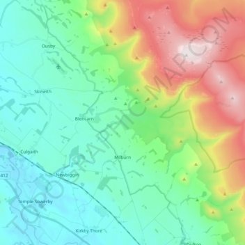
Nome: Mapa topográfico Milburn, altitude, relevo.
Local: Milburn, Westmorland and Furness, England, United Kingdom (54.63878 -2.55894 54.70728 -2.37259)
Altitude média: 320 m
Altitude mínima: 92 m
Altitude máxima: 893 m
Faça uma doação
Outros mapas topográficos
Clique em um mapa para visualizar sua topografia, sua altitude e seu relevo.
Faça uma doação
Kearstwick
United Kingdom > England > Westmorland and Furness > South Lakeland > Kirkby Lonsdale
Altitude média: 95 m