
Faça uma doação
Mapa topográfico Stubbington
Clique no mapa para exibir a altitude.
Faça uma doação
Sobre este mapa
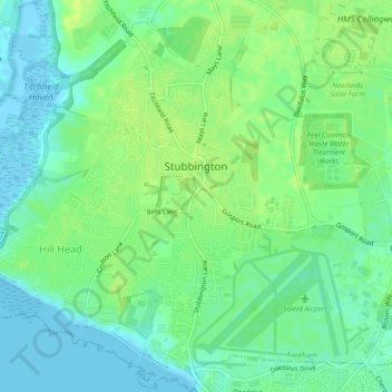
Nome: Mapa topográfico Stubbington, altitude, relevo.
Local: Stubbington, Fareham, Hampshire, England, United Kingdom (50.80894 -1.24424 50.83841 -1.20630)
Altitude média: 8 m
Altitude mínima: -5 m
Altitude máxima: 15 m
Faça uma doação
Outros mapas topográficos
Clique em um mapa para visualizar sua topografia, sua altitude e seu relevo.
Cocksford Firs East
United Kingdom > England > Hampshire > Basingstoke and Deane > Steventon
Altitude média: 153 m
Faça uma doação
Farnborough
United Kingdom > England > Hampshire > Rushmoor
Farnborough is located in the northeastern corner of the county of Hampshire, near the border with Surrey. The town occupies a valley setting, with the main urban area situated between the River Blackwater to the east and higher ground to the west. The topography gradually rises from the valley floor, reaching…
Altitude média: 82 m
Faça uma doação
Faça uma doação
Faça uma doação