
Faça uma doação
Mapa topográfico Chorley
Clique no mapa para exibir a altitude.
Faça uma doação
Sobre este mapa
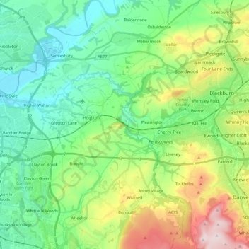
Nome: Mapa topográfico Chorley, altitude, relevo.
Local: Chorley, Lancashire, England, United Kingdom, River Darwen (53.70649 -2.68562 53.75960 -2.47107)
Altitude média: 123 m
Altitude mínima: 7 m
Altitude máxima: 401 m
Faça uma doação
Outros mapas topográficos
Clique em um mapa para visualizar sua topografia, sua altitude e seu relevo.
Coppull
United Kingdom > England > Lancashire > Chorley
The settlement has an Anglo Saxon name describing its topography derived from the Old English copp a hill top and hyll a hill. The township was variously recorded as Cophull and Cophulle in 1277, Copphull in 1351, Copthull in 1374 and Coppull from 1444.
Altitude média: 79 m
Belthorn Reservoir (disused)
United Kingdom > England > Lancashire > Hyndburn > Oswaldtwistle
Altitude média: 291 m
Faça uma doação
Faça uma doação
Farington Moss
United Kingdom > England > Lancashire > South Ribble > Farington Moss
Altitude média: 36 m
Faça uma doação