
Obrigado por apoiar este site ❤️
Faça uma doação
Faça uma doação
Mapa topográfico Stevenage
Clique no mapa para exibir a altitude.
Obrigado por apoiar este site ❤️
Faça uma doação
Faça uma doação
Sobre este mapa
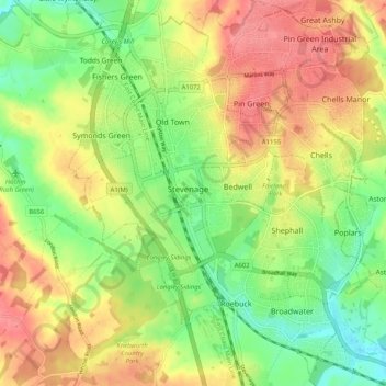
Nome: Mapa topográfico Stevenage, altitude, relevo.
Local: Stevenage, Hertfordshire, England, United Kingdom (51.86932 -0.23438 51.93243 -0.14680)
Altitude média: 108 m
Altitude mínima: 70 m
Altitude máxima: 147 m
Obrigado por apoiar este site ❤️
Faça uma doação
Faça uma doação
Outros mapas topográficos
Clique em um mapa para visualizar sua topografia, sua altitude e seu relevo.
Obrigado por apoiar este site ❤️
Faça uma doação
Faça uma doação
Bushey Heath
United Kingdom > England > Hertfordshire > Hertsmere > Bushey Heath
Altitude média: 110 m
Obrigado por apoiar este site ❤️
Faça uma doação
Faça uma doação
Bishops Stortford Elsan Point
United Kingdom > England > Hertfordshire > East Hertfordshire
Altitude média: 78 m