
Faça uma doação
Mapa topográfico Dormans Park
Clique no mapa para exibir a altitude.
Faça uma doação
Sobre este mapa
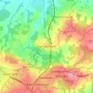
Nome: Mapa topográfico Dormans Park, altitude, relevo.
Altitude média: 96 m
Altitude mínima: 48 m
Altitude máxima: 144 m
Faça uma doação
Outros mapas topográficos
Clique em um mapa para visualizar sua topografia, sua altitude e seu relevo.
Farnham
United Kingdom > England > Surrey > Waverley
Farnham lies in the valley of the North Branch of the River Wey, which rises near Alton, merges with the South Branch at Tilford, and joins the River Thames at Weybridge. The mainly east–west alignment of the ridges and valleys has influenced the development of road and rail communications. The most…
Altitude média: 100 m
Faça uma doação
Epsom and Ewell
United Kingdom > England > Surrey
The borough is at a range of elevations, scaling the lower slopes of the North Downs and drains into a large stream which springs above the surface in Ewell, the Hogsmill River which drains into the Thames at Kingston. The borough comprises.
Altitude média: 73 m
Faça uma doação
Godalming
United Kingdom > England > Surrey > Waverley
Elevations vary between 36 m (118 ft) AOD by the Guildford Road Rugby Union ground and Broadwater lake at the River Wey's exit from Godalming into Peasmarsh, Shalford, and 106 m (348 ft) AOD where Quarter Mile meets Hambledon Road (both residential) in the south-east. Hurtmore Road is also residential: Upper…
Altitude média: 71 m
Faça uma doação
Horley
United Kingdom > England > Surrey > Reigate and Banstead
Horley is at an altitude of around 54 metres above mean sea level.
Altitude média: 58 m
Warlingham
United Kingdom > England > Surrey > Tandridge District
Elevations vary from 110m AOD at Woldingham Road, at the southernmost point of the parish, with a gentle increase in height through the village along the main road heading to the southeast, to the highest elevation (199.6m) at Limpsfield Road.
Altitude média: 163 m
Faça uma doação
Tandridge District
United Kingdom > England > Surrey > Tandridge District
The district contains parts of the North Downs Area of Outstanding Natural Beauty and the Weald. It also contains several woodlands and some open heathland. Elevations above sea level range from 267 m (876 ft) at Botley Hill, in the North Downs near Oxted, to 42 m (138 ft) near Edenbridge.
Altitude média: 114 m
Cobham
United Kingdom > England > Surrey > Elmbridge
The River Mole runs through Cobham, with a visitor area and well-surfaced path by the mill in the High Street, dividing the low-rise urban village/town centre from the remaining agricultural parts of Cobham in the west and south. This can flood small, old parts of the village centre in extreme rainfall.…
Altitude média: 28 m
Faça uma doação