
Faça uma doação
Mapa topográfico Godalming
Clique no mapa para exibir a altitude.
Faça uma doação
Godalming
Elevations vary between 36 m (118 ft) AOD by the Guildford Road Rugby Union ground and Broadwater lake at the River Wey's exit from Godalming into Peasmarsh, Shalford, and 106 m (348 ft) AOD where Quarter Mile meets Hambledon Road (both residential) in the south-east. Hurtmore Road is also residential: Upper Green/Hurtmore is at 102 m (335 ft) AOD. Immediately north and south of the town centre, steep hills reach 95 m (312 ft) AOD from 40–45 m (131–148 ft) AOD in the town centre itself.
Faça uma doação
Sobre este mapa
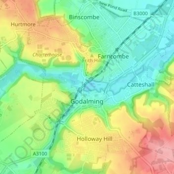
Nome: Mapa topográfico Godalming, altitude, relevo.
Local: Godalming, Waverley, Surrey, England, United Kingdom (51.16986 -0.64093 51.20806 -0.58489)
Altitude média: 71 m
Altitude mínima: 31 m
Altitude máxima: 133 m
Faça uma doação
Outros mapas topográficos
Clique em um mapa para visualizar sua topografia, sua altitude e seu relevo.
Camelsdale
United Kingdom > England > Surrey > Waverley > Haslemere > Shottermill
Altitude média: 166 m