
Faça uma doação
Mapa topográfico Walton-on-Thames
Clique no mapa para exibir a altitude.
Faça uma doação
Sobre este mapa
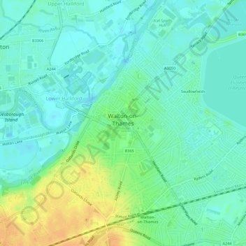
Nome: Mapa topográfico Walton-on-Thames, altitude, relevo.
Local: Walton-on-Thames, Surrey, England, United Kingdom (51.36827 -0.44253 51.40218 -0.39250)
Altitude média: 17 m
Altitude mínima: 7 m
Altitude máxima: 36 m
Faça uma doação
Outros mapas topográficos
Clique em um mapa para visualizar sua topografia, sua altitude e seu relevo.
Camelsdale
United Kingdom > England > Surrey > Waverley > Haslemere > Shottermill
Altitude média: 166 m
Faça uma doação
Faça uma doação
Thorpe
United Kingdom > England > Surrey > Borough of Runnymede
Elevations are modest but not flat, ranging between 14 and 20m Ordnance Datum as much of the area lies on thin alluvium overlying gravel beds laid over millennia by the River Thames which adjoins the traditional parish to the east.
Altitude média: 19 m
Esher
United Kingdom > England > Surrey > Elmbridge
Esher is an outlying suburb of London near the London-Surrey Border, and with Esher Commons at its southern end, the town marks one limit of the Greater London Built-Up Area. Esher has a linear commercial high street and is otherwise suburban in density, with varying elevations, few high rise buildings and…
Altitude média: 27 m
Faça uma doação
Caterham
United Kingdom > England > Surrey > Tandridge District
In 1840 Caterham contained a total of 477 residents (figures taken from that census, compiled in an 1848 topographical encyclopedia) and in 1848 468 acres (189 ha) of its 2,386 acres (966 ha) were common land. Similar to today, 175 acres (71 ha) mostly steeper acres were woodland.
Altitude média: 157 m
Faça uma doação
Faça uma doação