
Faça uma doação
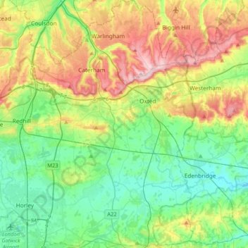
Mapa topográfico Tandridge District
Clique no mapa para exibir a altitude.
Faça uma doação
Tandridge District
The district contains parts of the North Downs Area of Outstanding Natural Beauty and the Weald. It also contains several woodlands and some open heathland. Elevations above sea level range from 267 m (876 ft) at Botley Hill, in the North Downs near Oxted, to 42 m (138 ft) near Edenbridge.
Faça uma doação
Sobre este mapa
Nome: Mapa topográfico Tandridge District, altitude, relevo.
Altitude média: 114 m
Altitude mínima: 34 m
Altitude máxima: 271 m
Faça uma doação
Outros mapas topográficos
Clique em um mapa para visualizar sua topografia, sua altitude e seu relevo.
Caterham
United Kingdom > England > Surrey > Tandridge District
In 1840 Caterham contained a total of 477 residents (figures taken from that census, compiled in an 1848 topographical encyclopedia) and in 1848 468 acres (189 ha) of its 2,386 acres (966 ha) were common land. Similar to today, 175 acres (71 ha) mostly steeper acres were woodland.
Altitude média: 157 m