
Obrigado por apoiar este site ❤️
Faça uma doação
Faça uma doação
Mapa topográfico Horley
Clique no mapa para exibir a altitude.
Obrigado por apoiar este site ❤️
Faça uma doação
Faça uma doação
Horley
Horley is at an altitude of around 54 metres above mean sea level.
Obrigado por apoiar este site ❤️
Faça uma doação
Faça uma doação
Sobre este mapa
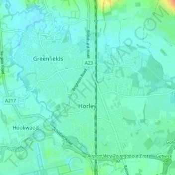
Nome: Mapa topográfico Horley, altitude, relevo.
Local: Horley, Reigate and Banstead, Surrey, England, United Kingdom (51.15959 -0.19230 51.19230 -0.12775)
Altitude média: 58 m
Altitude mínima: 50 m
Altitude máxima: 92 m
Obrigado por apoiar este site ❤️
Faça uma doação
Faça uma doação
Outros mapas topográficos
Clique em um mapa para visualizar sua topografia, sua altitude e seu relevo.