
Mapa topográfico Lancaster
Clique no mapa para exibir a altitude.
Sobre este mapa
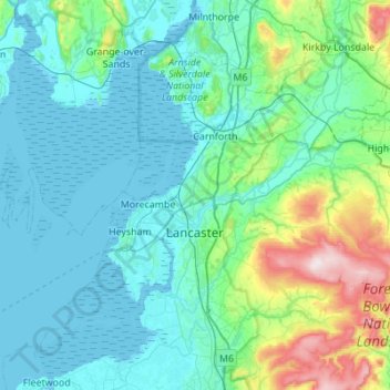
Nome: Mapa topográfico Lancaster, altitude, relevo.
Local: Lancaster, Lancashire, England, United Kingdom (53.91807 -2.98365 54.23956 -2.45873)
Altitude média: 84 m
Altitude mínima: 0 m
Altitude máxima: 561 m
Outros mapas topográficos
Clique em um mapa para visualizar sua topografia, sua altitude e seu relevo.
Rishton
United Kingdom > England > Lancashire > Hyndburn
Rishton is situated in an area of low moorland north east of Blackburn and north west of Accrington. Its elevation above sea level varies from 250 feet (76 m) in the east, where Norden Brook flows into the River Hyndburn, to 785 feet (239 m) on Rishton Height, north west of the town.
Altitude média: 151 m
Accrington
United Kingdom > England > Lancashire > Hyndburn
Geographical coordinates: 53° 46' 0" North, 2° 21' 0" West. Height above sea level: there is a spot height outside the Market Hall which is 133.5 metres (438 ft) the benchmark on the side of the neighbouring Town Hall is 441.10 feet (134.45 m). The highest height in the town is 320 metres (1,050 ft) which is…
Altitude média: 199 m
Billington and Langho
United Kingdom > England > Lancashire > Ribble Valley > Brockhall Village
Altitude média: 58 m
Old Langho
United Kingdom > England > Lancashire > Ribble Valley > Brockhall Village
Altitude média: 74 m
Bacup
United Kingdom > England > Lancashire > Borough of Rossendale
The geology and topography of the village lent itself to urbanisation and domestic industries; primitive weavers' cottages, coal pits and stone quarries were propelled by Bacup's natural supply of water power in the Early Modern period. The adoption of the factory system, which developed into the Industrial…
Altitude média: 337 m
Haslingden Grane
United Kingdom > England > Lancashire > Borough of Rossendale > Haslingden
Altitude média: 287 m
Colne Water
United Kingdom > England > Lancashire > Borough of Pendle > Laneshaw Bridge
Altitude média: 202 m
Larbreck
United Kingdom > England > Lancashire > Borough of Fylde > Little Eccleston
Altitude média: 12 m
Walton Summit
United Kingdom > England > Lancashire > South Ribble > Bamber Bridge
Altitude média: 67 m
Irwell Springs
United Kingdom > England > Lancashire > Borough of Rossendale > Weir
Altitude média: 365 m
Clowbridge
United Kingdom > England > Lancashire > Borough of Rossendale > Habergham Eaves
Altitude média: 319 m
Brungerley Park
United Kingdom > England > Lancashire > Ribble Valley > Clitheroe > Waddington
Altitude média: 77 m
Whitewell Bottom
United Kingdom > England > Lancashire > Borough of Rossendale > Sagar Holme
Altitude média: 281 m
Fold Head
United Kingdom > England > Lancashire > Borough of Rossendale > Healey
Altitude média: 294 m
Trough Gate
United Kingdom > England > Lancashire > Borough of Rossendale > Britannia
Altitude média: 341 m
Forest Holme
United Kingdom > England > Lancashire > Borough of Rossendale > Water
Altitude média: 318 m