
Mapa topográfico Fence
Clique no mapa para exibir a altitude.
Sobre este mapa
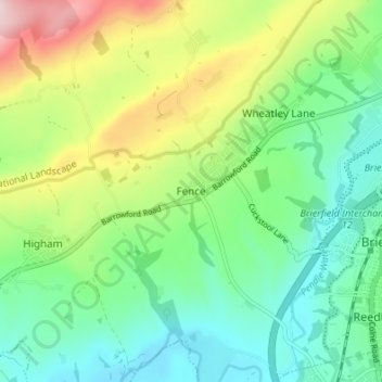
Nome: Mapa topográfico Fence, altitude, relevo.
Altitude média: 187 m
Altitude mínima: 83 m
Altitude máxima: 404 m
Outros mapas topográficos
Clique em um mapa para visualizar sua topografia, sua altitude e seu relevo.
Colne Water
United Kingdom > England > Lancashire > Borough of Pendle > Laneshaw Bridge
Altitude média: 202 m
Colne
United Kingdom > England > Lancashire > Borough of Pendle
Pendle Leisure Trust runs the Pendle Leisure Centre next to the railway station. The facility has two swimming pools, a fitness centre and gymnasium, sauna and sports hall. In summer 2013, the outdoor all-weather pitch was replaced by Urban Altitude. This outdoor aerial assault course is the first of its kind…
Altitude média: 197 m
Laneshaw Bridge
United Kingdom > England > Lancashire > Borough of Pendle > Laneshaw Bridge
Altitude média: 269 m
Barrowford
United Kingdom > England > Lancashire > Borough of Pendle > Barrowford
Altitude média: 161 m
Barnoldswick
United Kingdom > England > Lancashire > Borough of Pendle > Salterforth
Altitude média: 175 m
Colne
United Kingdom > England > Lancashire > Borough of Pendle
Pendle Leisure Trust runs the Pendle Leisure Centre next to the railway station. The facility has two swimming pools, a fitness centre and gymnasium, sauna and sports hall. In summer 2013, the outdoor all-weather pitch was replaced by Urban Altitude. This outdoor aerial assault course is the first of its kind…
Altitude média: 197 m
Barnoldswick
United Kingdom > England > Lancashire > Borough of Pendle > Salterforth
Altitude média: 175 m