
Mapa topográfico Rishton
Clique no mapa para exibir a altitude.
Rishton
Rishton is situated in an area of low moorland north east of Blackburn and north west of Accrington. Its elevation above sea level varies from 250 feet (76 m) in the east, where Norden Brook flows into the River Hyndburn, to 785 feet (239 m) on Rishton Height, north west of the town.
Sobre este mapa
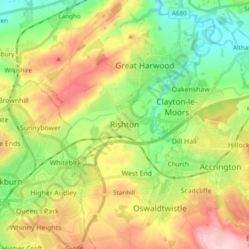
Nome: Mapa topográfico Rishton, altitude, relevo.
Altitude média: 151 m
Altitude mínima: 57 m
Altitude máxima: 283 m
Outros mapas topográficos
Clique em um mapa para visualizar sua topografia, sua altitude e seu relevo.
Oswaldtwistle Moor
United Kingdom > England > Lancashire > Hyndburn > Green Haworth > Cocker Brook
Altitude média: 300 m