
Faça uma doação
Mapa topográfico Otay Mesa
Clique no mapa para exibir a altitude.
Faça uma doação
Sobre este mapa
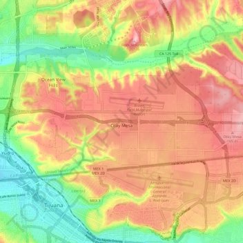
Nome: Mapa topográfico Otay Mesa, altitude, relevo.
Altitude média: 112 m
Altitude mínima: 12 m
Altitude máxima: 199 m
Faça uma doação
Outros mapas topográficos
Clique em um mapa para visualizar sua topografia, sua altitude e seu relevo.
San Diego
United States > California > San Diego County > San Diego
The climate in San Diego, like most of Southern California, often varies significantly over short geographical distances, resulting in microclimates. In San Diego, this is mostly because of the city's topography (the Bay, and the numerous hills, mountains, and canyons). Frequently, particularly during the "May…
Altitude média: 57 m
Faça uma doação
Lake Murray Reservoir
United States > California > San Diego County > San Diego > San Carlos
Altitude média: 178 m
Rancho Peñasquitos
United States > California > San Diego County > San Diego
The highest point in the community is Black Mountain, which rises to an elevation of 1,500 feet (460 m).
Altitude média: 157 m
Faça uma doação
Torrey Pines State Natural Reserve
United States > California > San Diego County > San Diego
Altitude média: 37 m
Faça uma doação
Faça uma doação