
Faça uma doação
Mapa topográfico Sorrento Valley
Clique no mapa para exibir a altitude.
Faça uma doação
Sobre este mapa
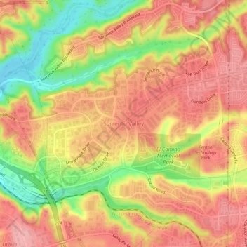
Nome: Mapa topográfico Sorrento Valley, altitude, relevo.
Altitude média: 88 m
Altitude mínima: 11 m
Altitude máxima: 134 m
Faça uma doação
Outros mapas topográficos
Clique em um mapa para visualizar sua topografia, sua altitude e seu relevo.
Lake Murray Reservoir
United States > California > San Diego County > San Diego > San Carlos
Altitude média: 178 m
Los Peñasquitos Canyon Preserve
United States > California > San Diego County > San Diego > Sorrento Valley
Altitude média: 95 m
Faça uma doação
Cabrillo National Monument
United States > California > San Diego County > San Diego
The Old Point Loma Lighthouse is the highest point in the park and has been a San Diego icon since 1855. The lighthouse was closed in 1891, and the New Point Loma Lighthouse opened at a lower elevation, as fog and low clouds often obscured the light at its location 129 meters (422 feet) above sea level. The…
Altitude média: 13 m
Faça uma doação
Mission Trails Regional Park
United States > California > San Diego County > San Diego > San Carlos
Altitude média: 178 m
Torrey Pines State Natural Reserve
United States > California > San Diego County > San Diego
Altitude média: 37 m
Faça uma doação