
Faça uma doação
Mapa topográfico San Diego
Clique no mapa para exibir a altitude.
Faça uma doação
San Diego
The climate in San Diego, like most of Southern California, often varies significantly over short geographical distances, resulting in microclimates. In San Diego, this is mostly because of the city's topography (the Bay, and the numerous hills, mountains, and canyons). Frequently, particularly during the "May gray/June gloom" period, a thick "marine layer" cloud cover keeps the air cool and damp within a few miles of the coast, but yields to bright cloudless sunshine approximately 5–10 miles (8–16 km) inland. Sometimes the June gloom lasts into July, causing cloudy skies over most of San Diego for the entire day. Even in the absence of June gloom, inland areas experience much more significant temperature variations than coastal areas, where the ocean serves as a moderating influence. Thus, for example, downtown San Diego averages January lows of 50 °F (10 °C) and August highs of 78 °F (26 °C). The city of El Cajon, just 10 miles (16 km) inland from downtown San Diego, averages January lows of 42 °F (6 °C) and August highs of 88 °F (31 °C).
Faça uma doação
Sobre este mapa
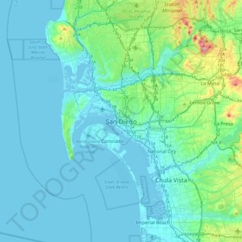
Nome: Mapa topográfico San Diego, altitude, relevo.
Altitude média: 57 m
Altitude mínima: -10 m
Altitude máxima: 471 m
Faça uma doação
Outros mapas topográficos
Clique em um mapa para visualizar sua topografia, sua altitude e seu relevo.
Lake Murray Reservoir
United States > California > San Diego County > San Diego > San Carlos
Altitude média: 178 m
Los Peñasquitos Canyon Preserve
United States > California > San Diego County > San Diego > Sorrento Valley
Altitude média: 95 m
Faça uma doação
Cabrillo National Monument
United States > California > San Diego County > San Diego
The Old Point Loma Lighthouse is the highest point in the park and has been a San Diego icon since 1855. The lighthouse was closed in 1891, and the New Point Loma Lighthouse opened at a lower elevation, as fog and low clouds often obscured the light at its location 129 meters (422 feet) above sea level. The…
Altitude média: 13 m
Faça uma doação
Mission Trails Regional Park
United States > California > San Diego County > San Diego > San Carlos
Altitude média: 178 m
Torrey Pines State Natural Reserve
United States > California > San Diego County > San Diego
Altitude média: 37 m
Faça uma doação