
Faça uma doação
Mapa topográfico Rancho Peñasquitos
Clique no mapa para exibir a altitude.
Faça uma doação
Rancho Peñasquitos
The highest point in the community is Black Mountain, which rises to an elevation of 1,500 feet (460 m).
Faça uma doação
Sobre este mapa
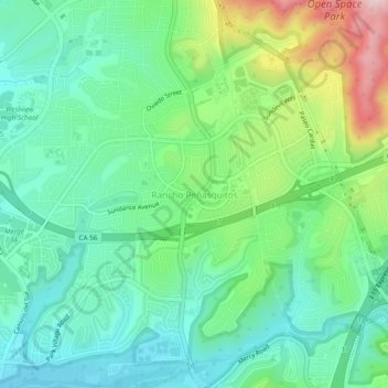
Nome: Mapa topográfico Rancho Peñasquitos, altitude, relevo.
Altitude média: 157 m
Altitude mínima: 62 m
Altitude máxima: 385 m
Faça uma doação
Outros mapas topográficos
Clique em um mapa para visualizar sua topografia, sua altitude e seu relevo.
Los Peñasquitos Canyon Preserve
United States > California > San Diego County > San Diego > Sorrento Valley
Altitude média: 95 m
Lake Murray Reservoir
United States > California > San Diego County > San Diego > San Carlos
Altitude média: 178 m
Faça uma doação
Cabrillo National Monument
United States > California > San Diego County > San Diego
The Old Point Loma Lighthouse is the highest point in the park and has been a San Diego icon since 1855. The lighthouse was closed in 1891, and the New Point Loma Lighthouse opened at a lower elevation, as fog and low clouds often obscured the light at its location 129 meters (422 feet) above sea level. The…
Altitude média: 13 m
Faça uma doação
Mission Trails Regional Park
United States > California > San Diego County > San Diego > San Carlos
Altitude média: 178 m
Torrey Pines State Natural Reserve
United States > California > San Diego County > San Diego
Altitude média: 37 m
Faça uma doação