
Faça uma doação
Mapa topográfico Baoruco
Clique no mapa para exibir a altitude.
Faça uma doação
Sobre este mapa
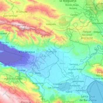
Nome: Mapa topográfico Baoruco, altitude, relevo.
Local: Baoruco, Dominican Republic (18.32524 -71.63363 18.65370 -70.98467)
Altitude média: 493 m
Altitude mínima: -44 m
Altitude máxima: 2.269 m
Faça uma doação
Outros mapas topográficos
Clique em um mapa para visualizar sua topografia, sua altitude e seu relevo.
Punta Cana
Dominican Republic > La Altagracia
Punta Cana, located at the easternmost tip of the Dominican Republic, is characterized by its predominantly flat terrain, with elevations averaging around 30 feet (9 meters) above sea level. This low-lying landscape contributes to the area's expansive white-sand beaches and extensive coconut palm groves. The…
Altitude média: 18 m
Faça uma doação
Faça uma doação
Faça uma doação
Pico Duarte
Dominican Republic > Santiago > San José de las Matas
Pico Duarte is the highest peak in the Dominican Republic, on the island of Hispaniola and in all the Caribbean. At 3,101 m (10,174 ft) above sea level, it gives Hispaniola the 16th-highest maximum elevation of any island in the world. Additionally, it is only 85 kilometres (53 miles) northeast of the region's…
Altitude média: 2.750 m
Faça uma doação
Faça uma doação
Jarabacoa
Dominican Republic > La Vega > Jarabacoa
Jarabacoa has a Tropical rainforest climate (Köppen climate classification Af ). Due to its high elevation in the interior it has warm days and lower temperatures at nights during most of the year, and temperate days and colder nights during winter months. Because of its climate, visitors have christened…
Altitude média: 617 m
Faça uma doação
Catalina Island
Dominican Republic > La Romana > La Romana > Caleta
The island itself is only 9.6 square kilometers in size, and is a diverse preservation of eco-systems including sand dunes, mangroves, and reefs. Formed out of coral stone, the island contains three overlapping plateaus. The highest elevation on the island is only 60 feet above sea level. The seas around the…
Altitude média: 2 m
San Juan de la Maguana
Dominican Republic > San Juan > San Juan de la Maguana
Owing to its location in a sheltered basin, San Juan de la Maguana has a relatively dry tropical savanna climate (Köppen Aw). Maxima are hot year-round, although the city’s moderate altitude lessens humidity somewhat and cools the mornings by around 4 to 5 °C (7 to 9 °F). There is a very pronounced dry…
Altitude média: 676 m
Faça uma doação
Pico Duarte
Dominican Republic > Santiago > San José de las Matas
Pico Duarte is the highest peak in the Dominican Republic, on the island of Hispaniola and in all the Caribbean. At 3,101 m (10,174 ft) above sea level, it gives the Dominican Republic the 16th-highest maximum elevation of any island in the world. Additionally, it is only 85 kilometres (53 miles) northeast of…
Altitude média: 2.750 m