
Obrigado por apoiar este site ❤️
Faça uma doação
Faça uma doação
Mapa topográfico Jarabacoa
Clique no mapa para exibir a altitude.
Obrigado por apoiar este site ❤️
Faça uma doação
Faça uma doação
Jarabacoa
Jarabacoa has a Tropical rainforest climate (Köppen climate classification Af ). Due to its high elevation in the interior it has warm days and lower temperatures at nights during most of the year, and temperate days and colder nights during winter months. Because of its climate, visitors have christened Jarabacoa as "The City of Everlasting Spring". Rain is abundant during most all the year.
Obrigado por apoiar este site ❤️
Faça uma doação
Faça uma doação
Sobre este mapa
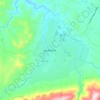
Nome: Mapa topográfico Jarabacoa, altitude, relevo.
Local: Jarabacoa, La Vega, 71402, Dominican Republic (19.08094 -70.68193 19.16094 -70.60193)
Altitude média: 617 m
Altitude mínima: 447 m
Altitude máxima: 1.203 m
Obrigado por apoiar este site ❤️
Faça uma doação
Faça uma doação