
Faça uma doação
Mapa topográfico Villa Verde
Clique no mapa para exibir a altitude.
Faça uma doação
Sobre este mapa
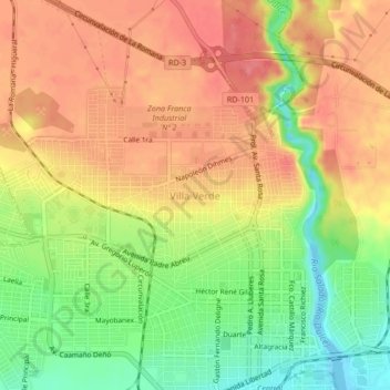
Nome: Mapa topográfico Villa Verde, altitude, relevo.
Local: Villa Verde, La Romana, Dominican Republic (18.41657 -68.99570 18.45657 -68.95570)
Altitude média: 45 m
Altitude mínima: -8 m
Altitude máxima: 78 m
Faça uma doação
Outros mapas topográficos
Clique em um mapa para visualizar sua topografia, sua altitude e seu relevo.
Catalina Island
Dominican Republic > La Romana > La Romana > Caleta
The island itself is only 9.6 square kilometers in size, and is a diverse preservation of eco-systems including sand dunes, mangroves, and reefs. Formed out of coral stone, the island contains three overlapping plateaus. The highest elevation on the island is only 60 feet above sea level. The seas around the…
Altitude média: 2 m