
Mapa topográfico Canterbury
Clique no mapa para exibir a altitude.
Sobre este mapa
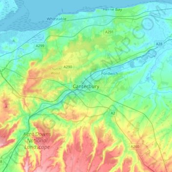
Nome: Mapa topográfico Canterbury, altitude, relevo.
Local: Canterbury, Kent, England, United Kingdom (51.17719 0.93720 51.38254 1.25007)
Altitude média: 51 m
Altitude mínima: -1 m
Altitude máxima: 178 m
Outros mapas topográficos
Clique em um mapa para visualizar sua topografia, sua altitude e seu relevo.
Ightham Common
United Kingdom > England > Kent > Tonbridge and Malling > Ightham
Altitude média: 145 m
Romney, Hythe and Dymchurch Railway
United Kingdom > England > Kent > Folkestone and Hythe > St. Mary in the Marsh
Altitude média: 1 m
Stowting Common
United Kingdom > England > Kent > Folkestone and Hythe > Lymbridge Green > Stowting Common
Altitude média: 148 m
Faversham Creek
United Kingdom > England > Kent > Borough of Swale > Faversham > Oare
Altitude média: 8 m
Pratling Street
United Kingdom > England > Kent > Tonbridge and Malling > Aylesford > Pratling Street
Altitude média: 49 m
Underground reservoir
United Kingdom > England > Kent > Tunbridge Wells > Hartley > Flishinghurst
Altitude média: 103 m
Faversham Creek
United Kingdom > England > Kent > Borough of Swale > Faversham > Oare
Altitude média: 11 m
Whitstable and Seasalter Golf Club
United Kingdom > England > Kent > Whitstable > Seasalter
Altitude média: 14 m
Kit's Coty
United Kingdom > England > Kent > Tonbridge and Malling > Bluebell Hill
Altitude média: 102 m
St Margaret's Bay
United Kingdom > England > Kent > Dover > St. Margaret's at Cliffe
Altitude média: 38 m