
Faça uma doação
Mapa topográfico Nairiri
Clique no mapa para exibir a altitude.
Faça uma doação
Sobre este mapa
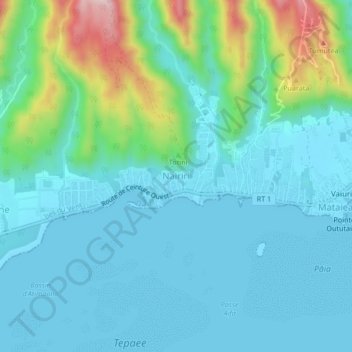
Nome: Mapa topográfico Nairiri, altitude, relevo.
Altitude média: 71 m
Altitude mínima: 0 m
Altitude máxima: 369 m
Faça uma doação
Outros mapas topográficos
Clique em um mapa para visualizar sua topografia, sua altitude e seu relevo.
Bora-Bora
France > French Polynesia > Bora-Bora
The bay of Tuuraapuo was the main crater of the volcano, whose collapsed southwestern edge only subsists still in the islets Toopua and Toopua-iti, which culminate respectively at 148 m (486 ft) and 17 m (56 ft), altitude. The volcanic rocks are of basaltic type, consisting mostly of alkaline basalts, some…
Altitude média: 11 m
Faça uma doação
Marquesas Islands
Although Polynesia tends to be associated with images of lush tropical vegetation, and the Marquesas lie within the tropics, they are remarkably dry. That is because they constitute the first major break for the prevailing easterly winds that arise from the (atmospherically) dry Humboldt Current. This subjects…
Altitude média: 3 m
Faça uma doação
Faça uma doação
Moho Tani
France > French Polynesia > Marquesas Islands > Hiva Oa
It is a high island, with its highest elevation (520 meters) in the south, and its overall shape resembles the back of a whale.
Altitude média: 41 m
Faça uma doação
Faça uma doação
Ra’iātea
There are three main mountain masses on the island, connected by lower ridges. The central mass includes Mount Tefatoaiti (1,017 m), the island's highest peak. The northern mass is known as the Temehani Plateau. The plateau generally undulates between 600 and 650 metres elevation, rising higher in places…
Altitude média: 62 m
Faça uma doação
Fatu Hiva
France > French Polynesia > Fatu Hiva
The mountain rainforest still harbours some endemic plants, such as Ochrosia fatuhivensis and Melicope fatuhivensis (syn. Pelea fatuhivensis), a tree of the Rutaceae family which may already be extinct. Pterophylla tremuloides is an endemic shrub which grows in low ridge top and cliff shrubland with…
Altitude média: 129 m
Ra’iātea
There are three main mountain masses on the island, connected by lower ridges. The central mass includes Mount Tefatoaiti (1,017 m), the island's highest peak. The northern mass is known as the Temehani Plateau. The plateau generally undulates between 600 and 650 metres elevation, rising higher in places…
Altitude média: 62 m
Austral Islands
At lower elevations, outside of cultivated areas, there are thickets of Hibiscus tiliaceus. Guava (Psidium guajava), probably introduced by Europeans, has also spread widely and forms extensive tangled stands up to middle elevations. However, large areas have been damaged by previous slash-and-burn and goat…
Altitude média: 0 m
Faça uma doação
Faça uma doação
Ra’iātea
There are three main mountain masses on the island, connected by lower ridges. The central mass includes Mount Tefatoaiti (1,017 m), the island's highest peak. The northern mass is known as the Temehani Plateau. The plateau generally undulates between 600 and 650 metres elevation, rising higher in places…
Altitude média: 62 m
Faça uma doação
Faça uma doação
Faça uma doação
Nuku Hiva
On the western edge of To'ovi'i rises Tekao, the island's highest peak, which reaches an elevation of 1,224 metres (4,016 ft). The western and northern edges of To'ovi'i are a mountain ridge, which catches much of the rain that waters the island.
Altitude média: 187 m
Papeete
Previously, during the construction of the Faʻaiere water tower with a capacity of 150,000 litres for the drinking water supply of the city of Papeʻetē, a difference in altitude of 37 metres (121 ft) was overcome with a light railway laid on a 220 metres (720 ft) long inclined plane. A winch driven by a…
Altitude média: 224 m
Faça uma doação
Fatu Hiva
France > French Polynesia > Fatu Hiva
The mountain rainforest still harbours some endemic plants, such as Ochrosia fatuhivensis and Melicope fatuhivensis (syn. Pelea fatuhivensis), a tree of the Rutaceae family which may already be extinct. Pterophylla tremuloides is an endemic shrub which grows in low ridge top and cliff shrubland with…
Altitude média: 129 m
Faça uma doação
Rapa
France > French Polynesia > Rapa
Rapa, also called Rapa Iti, or "Little Rapa", to distinguish it from Easter Island, whose Polynesian name is Rapa Nui, is the largest and only inhabited island of the Bass Islands in French Polynesia. An older name for the island is Oparo. The total land area including offshore islets is 40.5 km2 (15.6 sq mi).…
Altitude média: 53 m
Tikei
France > French Polynesia > Takaroa
Tikei, also known as Manu, Tikai and Tiku is an island in the Tuamotu group in French Polynesia. Tikei is not a typical Tuamotu atoll, as its former lagoon filled in. The island is 3.9 kilometres (2.4 miles) long, 1.6 kilometres (1.0 mile) wide, and has a land area of 4 square kilometres (1.5 square miles).…
Altitude média: 0 m
Faça uma doação
Faça uma doação
Akamaru
Akamaru is the third largest island in the Gambier Islands of French Polynesia. It is a small, rocky island with an area of approximately 2.6 km2 (1.0 sq mi). The island is located approximately 7 km (4.3 mi) southeast of Mangareva, which is the largest island of the whole Gambier Islands archipelago.…
Altitude média: 15 m
Faça uma doação
Faça uma doação
Faça uma doação
Faça uma doação
Faça uma doação
Nuku Hiva
France > French Polynesia > Marquesas Islands
On the western edge of To'ovi'i rises Tekao, the island's highest peak, which reaches an elevation of 1,224 metres (4,016 ft). The western and northern edges of To'ovi'i are a mountain ridge, which catches much of the rain that waters the island.
Altitude média: 187 m
Faça uma doação
Faça uma doação
Faça uma doação
Austral Islands
At lower elevations, outside of cultivated areas, there are thickets of Hibiscus tiliaceus. Guava (Psidium guajava), probably introduced by Europeans, has also spread widely and forms extensive tangled stands up to middle elevations. However, large areas have been damaged by previous slash-and-burn and goat…
Altitude média: 0 m
Tubuai
Hours of sunlight is about average for the Australs and is around 1970 hours per year, one of the lowest levels in Polynesia. The humidity is lower in contrast to Tahiti in the order of a few percent, mainly due to its higher latitude and its lower altitude (thus retaining fewer clouds).
Altitude média: 30 m
Faça uma doação
Nuku Hiva
On the western edge of To'ovi'i rises Tekao, the island's highest peak, which reaches an elevation of 1,224 metres (4,016 ft). The western and northern edges of To'ovi'i are a mountain ridge, which catches much of the rain that waters the island.
Altitude média: 187 m
Fatu Huku
France > French Polynesia > Marquesas Islands > Hiva Oa
The island is essentially a huge rock, looming steep-sided out of the ocean and rising to a flattened plateau with a maximum elevation of 361 metres (1,184 ft). Fatu Huku is the youngest of the volcanic Marquesas Islands, estimated to be only 1.3 million years old which accounts, in part, for its ruggedness as…
Altitude média: 8 m
Hiva Oa
France > French Polynesia > Marquesas Islands
Hiva Oa is the largest and most fertile of the southern Marquesas islands and second only to Nuku Hiva in size. Similar to all the larger Marquesas, Hiva Oa features steep cliffs abruptly rising from the ocean to a rugged interior spine of volcanic mountains, ridges, and deep, isolated valleys. Unlike most…
Altitude média: 79 m
Faça uma doação