
Faça uma doação
Mapa topográfico Akamaru
Clique no mapa para exibir a altitude.
Faça uma doação
Akamaru
Akamaru is the third largest island in the Gambier Islands of French Polynesia. It is a small, rocky island with an area of approximately 2.6 km2 (1.0 sq mi). The island is located approximately 7 km (4.3 mi) southeast of Mangareva, which is the largest island of the whole Gambier Islands archipelago. Akamaru's highest point rises to an elevation of 247 m (810 ft).
Faça uma doação
Sobre este mapa
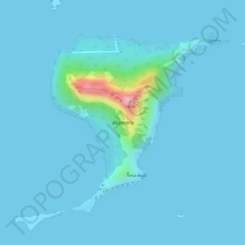
Nome: Mapa topográfico Akamaru, altitude, relevo.
Altitude média: 15 m
Altitude mínima: 0 m
Altitude máxima: 242 m
Faça uma doação
Outros mapas topográficos
Clique em um mapa para visualizar sua topografia, sua altitude e seu relevo.
Mont Orohena
France > French Polynesia > Windward Islands > Māhina
Mont Orohena is a mountain located in the South Pacific, on the island of Tahiti. With an elevation of 2,241 metres (7,352 ft) above sea level, it is the highest point of French Polynesia. Mont Orohena is an extinct volcano and ranks 7th in the world for topographic isolation.
Altitude média: 1.282 m
Faça uma doação
Faça uma doação
Faça uma doação
Faça uma doação
Faça uma doação
Faça uma doação
Faça uma doação
Faça uma doação
Fatu Huku
France > French Polynesia > Marquesas Islands > Hiva Oa
The island is essentially a huge rock, looming steep-sided out of the ocean and rising to a flattened plateau with a maximum elevation of 361 metres (1,184 ft). Fatu Huku is the youngest of the volcanic Marquesas Islands, estimated to be only 1.3 million years old which accounts, in part, for its ruggedness as…
Altitude média: 8 m
Faça uma doação
Faça uma doação
Faça uma doação
Faça uma doação