
Obrigado por apoiar este site ❤️
Faça uma doação
Faça uma doação
Mapa topográfico Moho Tani
Clique no mapa para exibir a altitude.
Obrigado por apoiar este site ❤️
Faça uma doação
Faça uma doação
Moho Tani
It is a high island, with its highest elevation (520 meters) in the south, and its overall shape resembles the back of a whale.
Obrigado por apoiar este site ❤️
Faça uma doação
Faça uma doação
Sobre este mapa
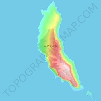
Nome: Mapa topográfico Moho Tani, altitude, relevo.
Altitude média: 41 m
Altitude mínima: -5 m
Altitude máxima: 516 m
Obrigado por apoiar este site ❤️
Faça uma doação
Faça uma doação
Outros mapas topográficos
Clique em um mapa para visualizar sua topografia, sua altitude e seu relevo.
Fatu Huku
France > French Polynesia > Marquesas Islands > Hiva Oa
The island is essentially a huge rock, looming steep-sided out of the ocean and rising to a flattened plateau with a maximum elevation of 361 metres (1,184 ft). Fatu Huku is the youngest of the volcanic Marquesas Islands, estimated to be only 1.3 million years old which accounts, in part, for its ruggedness as…
Altitude média: 8 m