
Obrigado por apoiar este site ❤️
Faça uma doação
Faça uma doação
Mapa topográfico Fatu Hiva
Clique no mapa para exibir a altitude.
Obrigado por apoiar este site ❤️
Faça uma doação
Faça uma doação
Fatu Hiva
The mountain rainforest still harbours some endemic plants, such as Ochrosia fatuhivensis and Melicope fatuhivensis (syn. Pelea fatuhivensis), a tree of the Rutaceae family which may already be extinct. Pterophylla tremuloides is an endemic shrub which grows in low ridge top and cliff shrubland with Metrosideros, Dicranopteris and Lycopodium from 700 to 850 metres elevation. A systematic study of the flora with the support of the Smithsonian Institution in 1988 revealed the number of 175 native, 21 endemic, and 136 anthropochoric plants.
Obrigado por apoiar este site ❤️
Faça uma doação
Faça uma doação
Sobre este mapa
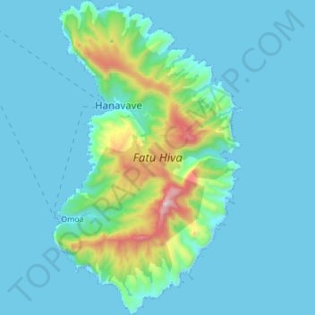
Nome: Mapa topográfico Fatu Hiva, altitude, relevo.
Altitude média: 129 m
Altitude mínima: -1 m
Altitude máxima: 1.019 m
Obrigado por apoiar este site ❤️
Faça uma doação
Faça uma doação