
Faça uma doação
Mapa topográfico Dumfries and Galloway
Clique no mapa para exibir a altitude.
Faça uma doação
Sobre este mapa
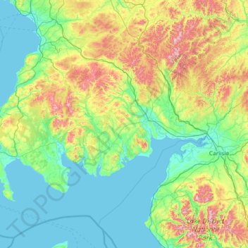
Nome: Mapa topográfico Dumfries and Galloway, altitude, relevo.
Local: Dumfries and Galloway, Scotland, United Kingdom (54.63324 -5.18765 55.46405 -2.85733)
Altitude média: 163 m
Altitude mínima: -1 m
Altitude máxima: 921 m
Faça uma doação
Outros mapas topográficos
Clique em um mapa para visualizar sua topografia, sua altitude e seu relevo.
Edinburgh
United Kingdom > Scotland > Edinburgh
Some have called Edinburgh the Athens of the North for a variety of reasons. The earliest comparison between the two cities showed that they had a similar topography, with the Castle Rock of Edinburgh performing a similar role to the Athenian Acropolis. Both of them had flatter, fertile agricultural land…
Altitude média: 104 m
Glasgow
United Kingdom > Scotland > Glasgow City
Glasgow itself was reputed to have been founded by the Christian missionary Saint Mungo in the 6th century. He established a church on the Molendinar Burn, where the present Glasgow Cathedral stands, and in the following years Glasgow became a religious centre. Glasgow grew over the following centuries. The…
Altitude média: 128 m
Aberdeen
United Kingdom > Scotland > Aberdeen
Two weather stations collect climate data for the area, Aberdeen/Dyce Airport, and Craibstone. Both are about 4 1⁄2 miles (7 km) to the north west of the city centre, and given that they are in close proximity to each other, exhibit very similar climatic regimes. Dyce tends to have marginally warmer daytime…
Altitude média: 52 m
Faça uma doação
Ben Nevis
United Kingdom > Scotland > Highland
Ben Nevis has a highland (alpine) maritime (oceanic) polar climate (ET climate in the Köppen classification). Ben Nevis's elevation, maritime location and topography frequently lead to cool and cloudy weather conditions, which can pose a danger to ill-equipped walkers. According to the observations carried…
Altitude média: 912 m
Aberlour
United Kingdom > Scotland > Moray
According to the 1846 A Topographical Dictionary of Scotland, "This parish, formerly called Skirdustan, signifying, in the Gaelic tongue, 'the division of Dustan', its tutelary saint, derived its present name from its situation at the mouth of a noisy burn, which discharges itself into the river Spey."
Altitude média: 160 m
Faça uma doação
Faça uma doação
Fort William
United Kingdom > Scotland > Highland
Fort William has an oceanic climate (Cfb) with moderate, but generally cool, temperatures and abundant precipitation. In the towns immediate vicinity, there are significant variations in elevation, which leads to some uninhabited areas near the town having a subpolar oceanic climate (Cfc), or, at the absolute…
Altitude média: 122 m
Faça uma doação
Faça uma doação
Elgin
United Kingdom > Scotland > Moray
Elgin is first documented in the Cartulary of Moray in 1190 AD. It was created a royal burgh in the 12th century by King David I of Scotland, and by that time had a castle on top of the present-day Lady Hill to the west of the town. The origin of the name Elgin is likely to be Celtic. It may derive from…
Altitude média: 26 m
Faça uma doação
Ben A'an
United Kingdom > Scotland > Stirling
Ben A'an is a hill in the Trossachs in Scotland. The pointed peak of its west top (454 metres or 1,490 feet in elevation) resembles a small mountain.
Altitude média: 283 m
Faça uma doação
Faça uma doação
Faça uma doação
Ailsa Craig
In a small glen above Ailsa Castle, a small freshwater body known as the Garry Loch is located at an altitude of 247 m (810 ft), with a depth of at least 17 feet.
Altitude média: 14 m
Faça uma doação
Mull of Kintyre
Ailsa Craig and the County Antrim coast of Ulster and Rathlin Island are all clearly visible from the Mull. On clearer days it is also possible to make out Malin Head in Inishowen in County Donegal in the west of Ulster, and the Ayrshire coast on the other side of Ailsa Craig. Other islands in the Firth of…
Altitude média: 84 m
Faça uma doação
Faça uma doação
Faça uma doação
Faça uma doação
Faça uma doação
Faça uma doação
Faça uma doação
Faça uma doação
Ballater
United Kingdom > Scotland > Aberdeenshire
Ballater (/ˈbælətər/, Scottish Gaelic: Bealadair) is a village in Aberdeenshire, Scotland, on the River Dee, immediately east of the Cairngorm Mountains. Situated at an elevation of 213 metres (699 feet), Ballater is a centre for hikers and known for its spring water, once said to cure scrofula. It is home…
Altitude média: 360 m
Faça uma doação
Coatbridge
United Kingdom > Scotland > North Lanarkshire
The topography of Coatbridge was an important feature in the town's development during the industrial revolution. Coatbridge rests 60 metres below the "Slamannan plateau" and neighbouring Airdrie sits on its edge. The low-lying flat ground of Coatbridge was a vital factor in the siting of the town's blast…
Altitude média: 99 m
Faça uma doação
Airdrie
United Kingdom > Scotland > North Lanarkshire
Airdrie's name first appeared in the Register of the Great Seal of Scotland (Registrum Magni Sigilii Regum Scotorum) in 1373 as Ardre. By 1546 it had become Ardry and by 1587 it was known as Ardrie. In 1630 it finally appeared in the Register as Airdrie. Given the topography of the area, the most likely…
Altitude média: 135 m
Faça uma doação
Alyth
United Kingdom > Scotland > Perth and Kinross
To the northeast of the town a hill fort, possibly of Pictish date or earlier, stands atop Barry (or 'barrow') Hill. It is considered to be one of the best preserved examples of an enclosed hilltop settlement in Scotland. The remains consist of massive collapsed stone ramparts that take advantage of the…
Altitude média: 125 m
Faça uma doação
Culloden Battlefield
United Kingdom > Scotland > Highland > Newlands of Culloden > Leanach
Since 2001, the site of the battle has undergone topographic, geophysical and metal detector surveys in addition to archaeological excavations. Interesting finds have been made in the areas on which the fiercest fighting occurred on the government left wing, particularly where Barrell's and Dejean's regiments…
Altitude média: 141 m
Faça uma doação
Faça uma doação
Faça uma doação