
Mapa topográfico Banffshire
Clique no mapa para exibir a altitude.
Sobre este mapa
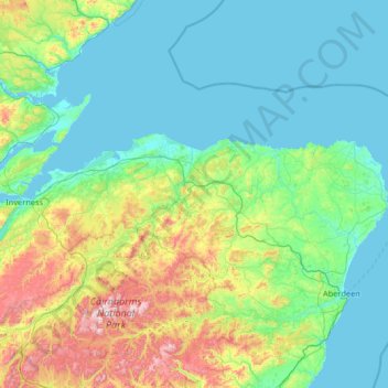
Nome: Mapa topográfico Banffshire, altitude, relevo.
Local: Banffshire, Scotland, AB38 9RN, United Kingdom (56.80000 -3.78333 58.20000 -2.38333)
Altitude média: 191 m
Altitude mínima: 0 m
Altitude máxima: 1.278 m
Outros mapas topográficos
Clique em um mapa para visualizar sua topografia, sua altitude e seu relevo.
City of Edinburgh
Edinburgh has been popularly called the Athens of the North since the early 19th century. References to Athens, such as Athens of Britain and Modern Athens, had been made as early as the 1760s. The similarities were seen to be topographical but also intellectual. Edinburgh's Castle Rock reminded returning…
Altitude média: 118 m
Ardnamurchan
United Kingdom > Scotland > Highland
The north western corner of Ardnamurchan consists of a lopolith (previously interpreted as a ring dyke) that has been exposed at the surface. Evidence for such a structure can be identified from the phenocrysts in the rock exposures around the area of interest which show plagioclase crystals aligned towards…
Altitude média: 73 m
Shetland
Walter Scott's 1822 novel The Pirate is set in "a remote part of Shetland", and was inspired by his 1814 visit to the islands. The name Jarlshof meaning "Earl's Mansion" is a coinage of his. Robert Cowie, a doctor born in Lerwick published the 1874 work.Shetland: Descriptive and Historical; Being a Graduation…
Altitude média: 4 m
Aberdeen City
Two weather stations collect climate data for the area, Aberdeen/Dyce Airport, and Craibstone. Both are about 4+1⁄2 miles (7 km) to the north west of the city centre, and given that they are in close proximity to each other, exhibit very similar climatic regimes. Dyce tends to have marginally warmer daytime…
Altitude média: 46 m
Orkney Islands
The southern group of islands surrounds Scapa Flow. Hoy, to the west, is the second largest of the Orkney Isles and Ward Hill at its northern end is the highest elevation in the archipelago. The Old Man of Hoy is a well-known seastack. Graemsay and Flotta are both linked by ferry to the Mainland and Hoy, and…
Altitude média: 7 m
Angus
Angus can be split into three geographic areas. To the north and west, the topography is mountainous. This is the area of the Grampian Mountains, Mounth hills and Five Glens of Angus, which is sparsely populated and where the main industry is hill farming. Glas Maol – the highest point in Angus at 1,068 m…
Altitude média: 254 m
Caithness
Caithness extends about 30 miles (48 km) north-south and about 30 miles (48 km) east-west, with a roughly triangular-shaped area of about 712 sq mi (1,840 km2). The topography is generally flat, in contrast to the majority of the remainder of the North of Scotland. Until the latter part of the 20th century…
Altitude média: 79 m
South Ayrshire
The number of hours of natural sunshine in South Ayrshire is controlled by the length of day and by cloudiness. In general, December is the dullest month and May or June the sunniest. Sunshine duration decreases with increasing altitude, increasing latitude and distance from the coast. Local topography also…
Altitude média: 151 m
East Ayrshire
East Ayrshire is located on the west coat of Scotland, sharing borders with the following neighbouring council areas; North Ayrshire, South Ayrshire, Dumfries and Galloway, East Renfrewshire and South Lanarkshire. Blackcraig Hill reaches an elevation of 2,298 feet (700 metres), the highest peak in East…
Altitude média: 225 m
South Uist
United Kingdom > Scotland > Western Isles
In the north west of the island at (57°20′N 07°20′W / 57.333°N 7.333°W / 57.333; -7.333), a missile testing range was built in 1957–58 to launch the Corporal missile, Britain and America's first guided nuclear weapon. This development went ahead despite significant protests, some locals…
Altitude média: 15 m
Ailsa Craig
In a small glen above Ailsa Castle, a small freshwater body known as the Garry Loch is located at an altitude of 247 m (810 ft), with a depth of at least 17 feet.
Altitude média: 14 m
Skye
United Kingdom > Scotland > Highland
Beyond Loch Snizort to the west of Trotternish is the Waternish peninsula, which ends in Ardmore Point's double rock arch. Duirinish peninsula is separated from Waternish by Loch Dunvegan, which contains the island of Isay. It is ringed by sea cliffs that reach 296 metres (971 feet) on the west at Waterstein…
Altitude média: 63 m
Glen Shee
United Kingdom > Scotland > Perth and Kinross > Spittal of Glenshee
The A93 road, part of General Wade's military road from Perth to Fort George, runs north through the glen and on into Glen Beag, where it crosses the Cairnwell Pass, which at an elevation of 2,200 feet (670 metres) is the highest public road in the UK. The road climbing to the summit is now wide and straight…
Altitude média: 387 m
Craignethan Castle
United Kingdom > Scotland > South Lanarkshire > Crossford > Tillietudlem
Altitude média: 121 m