
Mapa topográfico Ballater
Clique no mapa para exibir a altitude.
Ballater
Ballater (/ˈbælətər/, Scottish Gaelic: Bealadair) is a village in Aberdeenshire, Scotland, on the River Dee, immediately east of the Cairngorm Mountains. Situated at an elevation of 213 metres (699 feet), Ballater is a centre for hikers and known for its spring water, once said to cure scrofula. It is home to more than 1400 inhabitants and has had a long connection with the British Royal Family.
Sobre este mapa
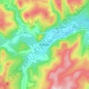
Nome: Mapa topográfico Ballater, altitude, relevo.
Local: Ballater, Aberdeenshire, Scotland, AB35 5QD, United Kingdom (57.00951 -3.08052 57.08951 -3.00052)
Altitude média: 360 m
Altitude mínima: 184 m
Altitude máxima: 645 m
Outros mapas topográficos
Clique em um mapa para visualizar sua topografia, sua altitude e seu relevo.
Dunnottar Castle
United Kingdom > Scotland > Aberdeenshire > Stonehaven > Mains of Dunnottar
Altitude média: 33 m
Cairngorm Mountains
United Kingdom > Scotland > Aberdeenshire
In terms of height, remoteness and the severe and changeable weather, the Cairngorms are the most arduous area in the United Kingdom. The plateau area has a Tundra climate (Köppen ET), and the shattered terrain is more like the high ground in high-arctic Canada or northern Norway than what is often observed…
Altitude média: 619 m
Forvie National Nature Reserve
United Kingdom > Scotland > Aberdeenshire > Newburgh
Altitude média: 15 m
Glen Tanar
United Kingdom > Scotland > Aberdeenshire > Aboyne
Glen Tanar, along with the side glens formed by the Water of Gairney and the Water of Allachy, comprises the third largest area of Caledonian Forest in Scotland, which grows from the valley floor up to an altitude of 450 metres. As a Caledonian Forest, the predominant tree species is Scots pine, although…
Altitude média: 389 m