
Faça uma doação
Mapa topográfico Gateside
Clique no mapa para exibir a altitude.
Faça uma doação
Sobre este mapa
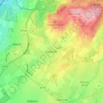
Nome: Mapa topográfico Gateside, altitude, relevo.
Local: Gateside, North Ayrshire, Scotland, KA15 2LF, United Kingdom (55.72792 -4.62898 55.76792 -4.58898)
Altitude média: 110 m
Altitude mínima: 27 m
Altitude máxima: 211 m
Faça uma doação
Outros mapas topográficos
Clique em um mapa para visualizar sua topografia, sua altitude e seu relevo.
Isle of Arran
United Kingdom > Scotland > North Ayrshire
The island has three endemic species of tree, the Arran whitebeams. These trees are the Scottish or Arran whitebeam (Sorbus arranensis), the bastard mountain ash or cut-leaved whitebeam (Sorbus pseudofennica) and the Catacol whitebeam (Sorbus pseudomeinichii). If rarity is measured by numbers alone they are…
Altitude média: 98 m
Faça uma doação