
Faça uma doação
Mapa topográfico Runyon Canyon Park
Clique no mapa para exibir a altitude.
Faça uma doação
Sobre este mapa
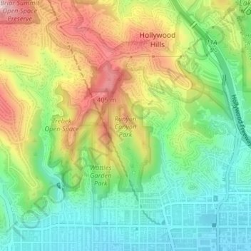
Nome: Mapa topográfico Runyon Canyon Park, altitude, relevo.
Altitude média: 235 m
Altitude mínima: 111 m
Altitude máxima: 414 m
Faça uma doação
Outros mapas topográficos
Clique em um mapa para visualizar sua topografia, sua altitude e seu relevo.
Santa Ynez Reservoir
United States > California > Los Angeles County > Los Angeles
Altitude média: 307 m
Mount Lukens
United States > California > Los Angeles County > Los Angeles
It is in the Sunland-Tujunga community within the northeast corner of the city of Los Angeles, above the Crescenta Valley. The summit, at 5,075 feet (1,547 m) in elevation, is the highest point within the city limits. The summit's elevation makes Los Angeles the city with the largest difference between high…
Altitude média: 1.176 m
Faça uma doação
Augustus F. Hawkins Natural Park
United States > California > Los Angeles County > Los Angeles
Altitude média: 55 m
Faça uma doação
Genesee Avenue Park
United States > California > Los Angeles County > Los Angeles
Altitude média: 33 m