
Faça uma doação
Mapa topográfico Pacific Palisades
Clique no mapa para exibir a altitude.
Faça uma doação
Pacific Palisades
Pacific Palisades was formally founded in 1921 by a Methodist organization, and in the years that followed became a refuge for Jewish artists and intellectuals fleeing the Holocaust. The Palisades would later be sought after by celebrities and other high-profile individuals seeking privacy. It is known for its seclusion and for being a close-knit community with a small-town feel, as well as its Mediterranean climate, hilly topography, natural environment, and abundance of parkland and hiking trails, 3-mile (4.8 km) strip of coastline, and for being home to a number of architecturally significant homes.
Faça uma doação
Sobre este mapa
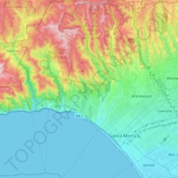
Nome: Mapa topográfico Pacific Palisades, altitude, relevo.
Altitude média: 196 m
Altitude mínima: -2 m
Altitude máxima: 653 m
Faça uma doação
Outros mapas topográficos
Clique em um mapa para visualizar sua topografia, sua altitude e seu relevo.
Santa Ynez Reservoir
United States > California > Los Angeles County > Los Angeles
Altitude média: 307 m
Mount Lukens
United States > California > Los Angeles County > Los Angeles
It is in the Sunland-Tujunga community within the northeast corner of the city of Los Angeles, above the Crescenta Valley. The summit, at 5,075 feet (1,547 m) in elevation, is the highest point within the city limits. The summit's elevation makes Los Angeles the city with the largest difference between high…
Altitude média: 1.176 m
Faça uma doação
Augustus F. Hawkins Natural Park
United States > California > Los Angeles County > Los Angeles
Altitude média: 55 m
Faça uma doação
Genesee Avenue Park
United States > California > Los Angeles County > Los Angeles
Altitude média: 33 m