
Faça uma doação
Mapa topográfico Rolling Hills Estates
Clique no mapa para exibir a altitude.
Faça uma doação
Sobre este mapa
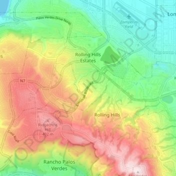
Nome: Mapa topográfico Rolling Hills Estates, altitude, relevo.
Altitude média: 198 m
Altitude mínima: 0 m
Altitude máxima: 453 m
Faça uma doação
Outros mapas topográficos
Clique em um mapa para visualizar sua topografia, sua altitude e seu relevo.
Santa Ynez Reservoir
United States > California > Los Angeles County > Los Angeles
Altitude média: 307 m
San Pedro Hill
United States > California > Los Angeles County > Rancho Palos Verdes
Altitude média: 285 m
Faça uma doação
Faça uma doação
Mount Wilson Observatory
United States > California > Los Angeles County > Mount Wilson
Altitude média: 1.421 m
Faça uma doação
Faça uma doação
Lake Elizabeth
United States > California > Los Angeles County
The lake, at 984 m (3,228 ft) in elevation, is within the Angeles National Forest. It is a natural perennial lake, but may dry up entirely during drought years. It is south of the western Antelope Valley.
Altitude média: 1.065 m
Mount Lukens
United States > California > Los Angeles County > Los Angeles
It is in the Sunland-Tujunga community within the northeast corner of the city of Los Angeles, above the Crescenta Valley. The summit, at 5,075 feet (1,547 m) in elevation, is the highest point within the city limits. The summit's elevation makes Los Angeles the city with the largest difference between high…
Altitude média: 1.176 m
Hollywood Riviera
United States > California > Los Angeles County > Torrance > Hollywood Riviera
Altitude média: 50 m
Faça uma doação
Faça uma doação
Faça uma doação
Faça uma doação
Avocado Heights
United States > California > Los Angeles County > Avocado Heights
Altitude média: 112 m
Faça uma doação
Santa Susana Mountains
United States > California > Los Angeles County > Unincorporated Chatsworth
Altitude média: 546 m
Topanga Oaks
United States > California > Los Angeles County > Topanga > Topanga Oaks
Altitude média: 371 m
Faça uma doação
Stoneview Nature Center
United States > California > Los Angeles County > Culver City
Altitude média: 64 m
Faça uma doação
Golden Shore Marine Biological Reserve
United States > California > Los Angeles County > Long Beach
Altitude média: 7 m
Faça uma doação
Adams Square
United States > California > Los Angeles County > Glendale > Adams Square
Altitude média: 168 m
Faça uma doação
Edward Vincent Jr. Park
United States > California > Los Angeles County > Inglewood
Altitude média: 56 m
Faça uma doação
Augustus F. Hawkins Natural Park
United States > California > Los Angeles County > Los Angeles
Altitude média: 55 m
Altacanyada
United States > California > Los Angeles County > La Cañada Flintridge
Altitude média: 584 m
Faça uma doação
La Puerta Sports Park
United States > California > Los Angeles County > Claremont
Altitude média: 471 m
Faça uma doação
Genesee Avenue Park
United States > California > Los Angeles County > Los Angeles
Altitude média: 33 m
Faça uma doação
East Rancho Dominguez County Park
United States > California > Los Angeles County > East Compton
Altitude média: 22 m