
Faça uma doação
Mapa topográfico Kasaragod district
Clique no mapa para exibir a altitude.
Faça uma doação
Kasaragod district
The district is the northernmost district of the State of Kerala. Kasargod is located at 12°30′N 75°00′E / 12.5°N 75.0°E / 12.5; 75.0. It has an average elevation of 19 metres (62 feet). Ranipuram or Madathumala (1016m) peak is the highest peak in the Kasargod district of Kerala, located in the Ranipuram Wildlife Sanctuary.
Faça uma doação
Sobre este mapa
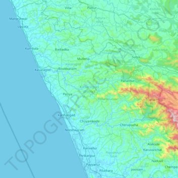
Nome: Mapa topográfico Kasaragod district, altitude, relevo.
Local: Kasaragod district, Kerala, India (12.04834 74.86407 12.79606 75.43232)
Altitude média: 127 m
Altitude mínima: -2 m
Altitude máxima: 1.651 m
Faça uma doação
Outros mapas topográficos
Clique em um mapa para visualizar sua topografia, sua altitude e seu relevo.
Kottayam
Kottayam has an average elevation of 3 metres (9.8 ft) above sea level. and is situated in the basin of the Meenachil River and in the basin of the Vembanad backwaters, which are formed from several streams in the Western Ghats in Idukki district. According to the division of places in Kerala based on…
Altitude média: 19 m
Faça uma doação
Thiruvalla
India > Kerala > Thiruvalla
Thiruvalla lies at an altitude of 9 meters above sea level on the basin of the Pamba and Manimala rivers. Thiruvalla is dotted with several natural canal streams (called "thodu" in Malayalam) like Chanthathodu, Manippuzha, Mullelithodu, and several others. The city area has riverine alluvial soil, and eastern…
Altitude média: 10 m
Faça uma doação
North Paravur
Paravur is located at 10.14° N 76.7° E[1]. It has an average elevation of 10 metres (32 feet). The town is situated at north end of Ernakulam district and bordering with Thrissur district. The towns in Thrissur district like Kodungallore, Mala, Chalakudy and the towns Kalamassery, Aluva, Angamaly, Vypin…
Altitude média: 5 m
Faça uma doação
Vadakara
Vatakara is located at 11°36′N 75°35′E / 11.60°N 75.58°E / 11.60; 75.58 and has an average elevation of 15 m (49 ft). It is situated about 49 km to the north of Kozhikode City, approximately 44 km to the south of Kannur City, and adjacent to Mahé. The town lies by the side of a river…
Altitude média: 12 m
Faça uma doação
Faça uma doação
Faça uma doação
Ponkunnam
India > Kerala > Kanjirappally
Ponkunnam is a census town in Kerala, India, part of Kottayam district under Kanjirappally taluk. Ponkunnam literally means golden mountain (ponn = gold, kunn = mountain). Nearby towns are Kanjirappalli, Pampady , Manimala and Pala. This part of Kerala is famous for its fertile land and rubber plantations. It…
Altitude média: 83 m
Faça uma doação
Faça uma doação
Kanhangad
Kanhangad lies at 12°18′0″N 75°5.4′0″E in the geographic map of Kasaragod. It is a coastal town which has a varied topography with plain areas in the centre of the city. The landscape is dominated by the characteristic coconut palms accompanying rolling hills and streams flowing into the sea. In the…
Altitude média: 18 m
Faça uma doação
Faça uma doação
Faça uma doação
Angamoozhy
Angamoozhy is geographically a high-range area (Malanadu) situated in the south eastern part of Kerala and very close to the Western ghats mountain ranges. It has an average elevation of 18 m (59 ft) above sea level.
Altitude média: 233 m
Faça uma doação
Faça uma doação
Faça uma doação
Faça uma doação
Mannarkkad
Mannarkkad is located at 10°59′N 76°28′E / 10.98°N 76.47°E / 10.98; 76.47. It has an average elevation of 76 m (249 ft). Mannarkkad is located 36 km north-west of district headquarters Palakkad, along National Highway 966 and 100 km north west of Kozhikode. Mannarkkad is located in the…
Altitude média: 80 m
Faça uma doação
Faça uma doação
Faça uma doação
Faça uma doação
Faça uma doação
Faça uma doação
Shoranur
India > Kerala > Ottappalam
Shoranur is located at 10°46′N 76°17′E / 10.77°N 76.28°E / 10.77; 76.28. It has an average elevation of 49 metres (160 feet).
Altitude média: 47 m
Faça uma doação
Faça uma doação
Faça uma doação
Faça uma doação