
Faça uma doação
Mapa topográfico Kottayam
Clique no mapa para exibir a altitude.
Faça uma doação
Kottayam
Kottayam has an average elevation of 3 metres (9.8 ft) above sea level. and is situated in the basin of the Meenachil River and in the basin of the Vembanad backwaters, which are formed from several streams in the Western Ghats in Idukki district. According to the division of places in Kerala based on altitudes, Kottayam is classified as being a midland area. The general soil type is alluvial soil. The vegetation is mainly tropical evergreen and moist deciduous type.
Faça uma doação
Sobre este mapa
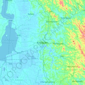
Nome: Mapa topográfico Kottayam, altitude, relevo.
Local: Kottayam, Kottayam District, Kerala, 686001, India (9.43156 76.36216 9.75156 76.68216)
Altitude média: 19 m
Altitude mínima: -4 m
Altitude máxima: 157 m
Faça uma doação
Outros mapas topográficos
Clique em um mapa para visualizar sua topografia, sua altitude e seu relevo.