
Faça uma doação
Mapa topográfico Kanhangad
Clique no mapa para exibir a altitude.
Faça uma doação
Kanhangad
Kanhangad lies at 12°18′0″N 75°5.4′0″E in the geographic map of Kasaragod. It is a coastal town which has a varied topography with plain areas in the centre of the city. The landscape is dominated by the characteristic coconut palms accompanying rolling hills and streams flowing into the sea. In the East, there are hilly areas of Madikai . The western region has powdered sand and a mix of laterite and alluvial soil in the areas between. The hilly areas typically consists of red sand.
Faça uma doação
Sobre este mapa
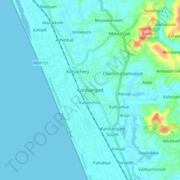
Nome: Mapa topográfico Kanhangad, altitude, relevo.
Local: Kanhangad, Hosdurg, Kasaragod District, Kerala, 671315, India (12.27356 75.05246 12.35356 75.13246)
Altitude média: 18 m
Altitude mínima: -6 m
Altitude máxima: 169 m
Faça uma doação
Outros mapas topográficos
Clique em um mapa para visualizar sua topografia, sua altitude e seu relevo.